Fastest Turnaround Times In The Surveying Industry!


Sydney’s skyline is changing fast, and not just because of cranes and concrete. Digital surveying is transforming the way data is captured and applied across the city. At MCS Surveyors Sydney, we’ve seen how drones, laser scanning, and AI are making projects faster, more precise, and more efficient. From mapping waterfront developments to scanning historic buildings, these tools deliver results that property owners and developers can rely on, while challenging traditional methods.
In this guide, we’ll explore how digital surveying is innovating Sydney’s urban landscape, from reducing costs and delays to supporting smarter planning and greener infrastructure. Let’s get started!
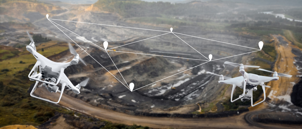
Surveying is no longer limited to tape measures, total stations, and manual mapping. The industry has entered a digital era, with drones and laser scanning standing out as two of the most transformative innovations. These technologies are changing the way surveyors capture, analyse, and present data, offering greater speed, reliable measurements, and safety compared to traditional methods. This shift isn’t just about replacing old methods with new gadgets; it’s about unlocking capabilities that make projects smoother, safer, and more sustainable.
Drones and laser scanning have transformed modern surveying. For property owners and developers, they offer the precision, efficiency, and comprehensive data that traditional methods often struggle to deliver.
One of the advantages of using drones and laser scanning is the heightened pinpoint detail they provide. Drones equipped with high-resolution cameras and LiDAR sensors can capture detailed aerial images and 3D models of the terrain. This data enables surveyors to create precise topographic maps and models, ensuring that property boundaries and land features are accurately represented. For you as a developer, this level of detail means fewer errors during construction and more confidence in every decision you make.
What used to take weeks with manual methods can now be done in days. By using drones and laser scanning, we save you time and cut costs without compromising accuracy, so your project moves forward smoothly. In contrast, drones can cover large areas swiftly, and laser scanning technology allows for rapid data collection with minimal human intervention. This efficiency translates to maximised resources, as the reduced labour and time requirements lower overall project expenses. These savings can be redirected towards other critical aspects of their projects.
Surveying often involves accessing challenging or hazardous environments. Drones mitigate these risks by allowing surveyors to conduct aerial surveys without the need to physically traverse dangerous terrain. Similarly, laser scanning can be performed from a safe distance, minimising the need for surveyors to work in potentially harmful conditions. By enhancing risk reduction, these technologies protect professionals and the integrity of the property being surveyed.
Drones and laser scanners can capture data on a scale that traditional methods can’t match. This means surveyors can provide property owners and developers with a detailed picture of their site. With advanced software, that data is transformed into 3D models, orthophotos, and other outputs that guide planning and design. The result? A clearer, more informed process that reduces risks and keeps projects aligned with goals.
Despite the clear benefits, the adoption of drones and laser scanning technology in surveying has faced resistance, particularly among experienced professionals accustomed to traditional methods. Addressing these barriers is crucial for the widespread acceptance and integration of these innovative tools.
A primary barrier to adoption is the knowledge gap regarding how to operate and integrate these technologies into existing workflows. Providing comprehensive education and training programmes for surveyors and related professionals is essential. These should cover the technical aspects of operating drones and laser scanners, as well as the software used to process the collected data. By equipping professionals with the skills they need, the industry can facilitate a smoother transition to modern surveying techniques.
Experienced professionals may be hesitant to invest in new technologies without a clear understanding of the return on investment (ROI). Demonstrating the financial and operational benefits of drones and laser scanning is crucial to overcoming this barrier. Case studies and real-world examples that highlight cost savings, improved project timelines, and enhanced accuracy can be powerful tools in persuading sceptics of the value these technologies bring.
Using drones in surveying comes with strict aviation and data protection rules, which can feel daunting at first. Clear guidance on how to navigate these requirements makes adoption easier and safer. Professional associations and industry bodies also play a key role, setting standards and offering resources that give surveyors confidence in compliance.
For seasoned surveyors, trust in technology is a significant hurdle. Establishing trust requires consistent performance, reliability, and demonstrable accuracy from drones and laser scanning systems. We use technology that we’ve tested in the toughest conditions, so our clients can trust the data we deliver. As professionals witness the consistent benefits and reliability of these technologies, trust will naturally grow.
In Sydney’s diverse and fast-paced construction environment, surveyors are constantly challenged by harsh conditions. To maintain accuracy and efficiency in such demanding settings, rugged technology has become a cornerstone of modern surveying. For professionals, this translates into reliable surveys that meet deadlines and comply with strict planning requirements, even when projects are carried out under challenging conditions.
The impact of rugged technology is best seen in action across urban and suburban projects. As experts, we’ve used these solutions to meet the demands of clients who require precision and speed despite complex site conditions.
The integration of artificial intelligence (AI) and advanced data processing technologies is transforming how we capture, analyse, and interpret data. These advancements are not only enhancing the precision and efficiency of surveys but also transforming raw data into actionable insights, while significantly reducing human error through automated analysis. In this section, we explore how these technological innovations are redefining workflow practices in Sydney.
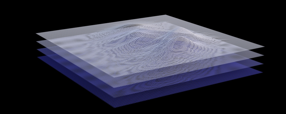
The first step in converting raw inputs into usable outcomes begins with capturing high-quality data. Modern surveying technologies, such as LiDAR (Light Detection and Ranging) and UAV (Unmanned Aerial Vehicle) photogrammetry, enable surveyors to collect vast amounts of in-depth information with unprecedented accuracy. These tools provide detailed topographical information and 3D models that form the basis for further analysis.
Once the data is collected, AI-powered software takes over to process and interpret the information. Machine learning algorithms can sift through large datasets to identify patterns and anomalies that might be missed by human analysts. These algorithms are trained to recognise specific features, such as property boundaries, elevation changes, and infrastructure elements, making the data more comprehensible and usable.
With AI-driven processing, we see results in real time, whether it’s identifying risks before construction or making design changes on the spot. This capability is valuable in dynamic environments where conditions can change rapidly. Instant access to insights enables quicker decision-making, allowing projects to proceed with confidence and agility.
One of the advantages of AI in land surveying is the reduction of manual data entry, a process prone to human error. Automated systems can accurately capture and input data directly from the field, eliminating the risk of transcription errors and ensuring the integrity of the information.
AI algorithms are capable of performing complex calculations with a level of consistency that far surpasses manual methods. By automating these tasks, surveyors can achieve higher accuracy in measurements and mapping, which is crucial for ensuring compliance with regulatory standards and avoiding costly mistakes.
By using AI-powered analysis, we spot potential errors before they affect your project. This means fewer risks, fewer delays, and greater confidence that every stage of development is built on reliable data. These systems can flag inconsistencies or deviations from expected patterns, prompting further investigation. This proactive approach to error detection helps prevent issues before they escalate, saving time and resources in the long run.
As machine learning models are exposed to more data, they continue to learn and improve their performance. This continuous improvement means that the more these systems are used, the better they become at analysing data and reducing errors. This iterative learning process ensures that AI technologies remain at the forefront of precision and reliability in land surveying.
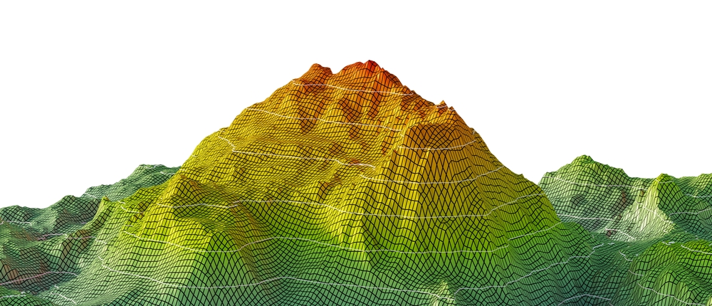
In a city like Sydney, where space is limited and development is constant, clear and reliable planning tools are essential. This is where 3D modelling and visualisation step in, transforming traditional survey data into interactive, digital environments that everyone can understand. By turning complex measurements into realistic visual models, surveyors help developers, architects, and councils see beyond the numbers and make better-informed decisions.
Communication is a challenging aspect of the planning and development process, especially when multiple parties are involved. Traditional 2D drawings and technical reports can often be difficult for non-specialists to interpret, leading to misunderstandings and costly mistakes.
With 3D modelling, we give you a clear, visual plan that everyone can understand. Instead of wading through complex drawings, you can see exactly how your project will look. Interactive models allow stakeholders to “walk through” a proposed development virtually, explore different viewpoints, and identify potential conflicts before construction begins. By aligning stakeholders early, 3D surveys foster collaboration, reduce communication errors, and ensure that all parties share a common vision of the project.
Rapid urban growth and infrastructure expansion make 3D modelling an invaluable tool. From small-scale residential planning to city-shaping infrastructure, visualisation supports smarter decision-making and reduces risks.
Digital surveying is becoming a game-changer for sustainable urban development. As cities grow and businesses invest in greener futures, advanced surveying tools are helping reduce environmental impact and support eco-friendly planning.
Traditional surveying methods often require extensive physical presence and interaction with the terrain, which can lead to soil compaction, disruption of local flora and fauna, and even alterations to the landscape. Digital surveying, on the other hand, utilises advanced tools such as drones, LiDAR, and GPS technology to collect data remotely.
By reducing the need for heavy machinery and large survey teams, digital surveying preserves natural environments. High-resolution aerial data can be captured remotely, minimising ecological impact, an essential advantage in sensitive areas.
Green infrastructure refers to the network of natural and semi-natural systems that provide environmental, economic, and social benefits. It includes parks, green roofs, rain gardens, and more. Digital surveying supports the development and maintenance of green infrastructure by providing precise data that helps in planning and execution.
Through accurate topographical analyses and 3D modelling, digital surveying enables planners and architects to design infrastructure that works with the natural landscape rather than against it. This not only enhances the aesthetic and recreational value of urban spaces but also improves biodiversity, water management, and air quality.
Digital surveying also plays a role in supporting conservation efforts. The ability to capture detailed, accurate data over large areas means that conservationists can monitor ecosystems with greater precision. For example, drones equipped with high-resolution cameras and sensors can be used to track changes in vegetation, wildlife habitats, and land use without the need for intrusive ground surveys.
This non-invasive monitoring is essential for identifying potential threats to ecosystems early and implementing measures to protect endangered species and habitats. Additionally, digital surveying data can be used to create detailed maps and models that aid in the formulation of conservation strategies, ensuring that efforts are targeted and effective.
Ensuring that the next generation of surveyors is well-equipped with the necessary skills and training is important. As the industry continues to integrate advanced technologies, our approach to education and professional development must also adapt. Here, we explore how traditional techniques are blended with modern tools.
While digital tools and technologies are revolutionising the field of surveying, the foundational principles and techniques remain crucial. Surveyors must still possess a solid understanding of traditional methods, such as topographic surveys, boundary determinations, and the use of instruments like theodolites and total stations. These skills form the basis upon which new technologies can be layered.
To keep pace with technological advancements, continuous professional development is vital. Upskilling programmes are designed to ensure that surveyors remain at the forefront of the industry.
Collaborations between educational institutions, technology providers, and surveying firms are essential in developing a workforce that is skilled and adaptable.
Sydney is a city in motion. From major infrastructure projects to the rise of new residential hubs and commercial districts, the demand for accurate and forward-looking surveying has never been greater. As the city grows, so too does the role of technology in shaping its future.
The next decade will see technologies that push the boundaries of what surveying can achieve in Sydney. Some anticipated breakthroughs include:
The role of surveyors will become increasingly pivotal, not just in providing data, but in shaping the way the city grows. Surveyors act as the bridge between technology, planning, and real-world outcomes. Key contributions include:
In conclusion, digital surveying is redefining urban landscape, with drones, laser scanning, rugged tools, AI, and 3D visualisation. They deliver faster, smarter, and more sustainable results for property owners and developers. At MCS Surveyors, we bring together proven expertise and the latest technology to give you the clarity and confidence you need for your next project. Planning a development in Sydney? Let’s build it on solid ground with data you can trust.