Fastest Turnaround Times In The Surveying Industry!
Surveyors Wollongong: Driving Sustainable Land Development
August 20, 2025
Sustainable development isn’t just a global buzzword; it’s something communities are facing every day. With challenges like flooding, erosion, and urban heat on the rise, the way we plan and manage land today will determine how prepared our communities will be tomorrow. At MCS Surveyors Wollongong, we play a role in shaping this future, using data-driven strategies and modern technology to ensure growth supports both community needs and climate resilience. We use tools alongside strong community collaboration. This approach ensures development remains smart, balanced, and sustainable. By aligning local projects with global sustainability goals, we’re helping grow in harmony with its coastline, its people, and its natural assets.
In this guide, we’ll explore how surveyors are driving climate-responsible land development and why these practices matter for the future. Let's get started!
The Surveyor’s Role in Climate-Responsible Land Development
Surveyors are no longer just responsible for measuring boundaries and mapping land. Today, they are central to shaping how communities grow in ways that respect the environment and people’s needs. In many ways, they’re at the frontline of sustainable development. Their expertise ensures that every decision about land use considers climate impacts, resource efficiency, and long-term stability.
How Surveyors Drive Climate-Responsible Development
Mapping High-Risk Areas: We map high-risk areas using various tools. This allows them to identify zones vulnerable to flooding, erosion, or heat island formation and guide planners away from these risks. This helps guide planners and developers away from vulnerable areas.
Integrating Climate Data: Historical weather patterns and predictive climate models are incorporated into survey designs, ensuring new developments are climate-adapted and able to withstand rising sea levels, extreme weather, and changing temperatures.
Protecting Natural Assets: Surveyors consider biodiversity corridors, wetlands, and coastal systems to reduce the impact of urban sprawl.
Promoting Smarter Land Use: Whether it’s recommending higher-density housing to reduce land consumption or planning green spaces for cooling and stormwater management, we influence choices that make cities more sustainable.
Engaging Communities and Councils: Surveyors bridge developers, councils, and residents, ensuring growth reflects community values and supports climate resilience.
Land Governance Reforms
Sustainable development requires protecting coastlines while meeting evolving policies and governance frameworks. We make sure land use decisions stay aligned with local, state, and national reforms.
Compliance with Planning Regulations: Surveyors ensure developments align with environmental and zoning rules that prioritise sustainability.
Supporting Council Initiatives: We work with local councils to deliver infrastructure that supports regional growth strategies while preserving green spaces.
Transparent Land Use Planning: Accurate land records provide clarity for landowners and councils, reducing disputes and streamlining approvals.
Integrating Indigenous Land Values: Modern surveying practices increasingly acknowledge cultural heritage and Indigenous land rights, ensuring that development is socially and environmentally responsible.
Global Goals
Surveyors don’t work in isolation; they are part of a global movement towards climate responsibility. Their efforts directly support the United Nations’ Sustainable Development Goals (SDGs), particularly those focused on sustainable cities, climate action, and life on land.
Sustainable Cities & Communities (SDG 11): Encouraging urban layouts that reduce environmental impact and improve liveability.
Climate Action (SDG 13): Using technology and data to adapt land use practices to a changing climate.
Life on Land (SDG 15): Safeguarding ecosystems and biodiversity through thoughtful land management.
Partnerships for the Goals (SDG 17): Working with councils, developers, and residents to foster collaboration and shared responsibility for sustainability.
Sustainable Surveying Solutions for Coastal and Urban Growth
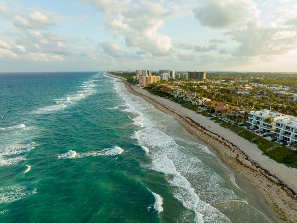
As Wollongong and Shellharbour continue to expand, the challenge lies in ensuring Wollongong and Shellharbour grow safely without placing homes, businesses, or ecosystems at risk. Sustainable surveying solutions provide the foundation for responsible land development, blending advanced technology with forward-thinking planning. Surveyors don’t just chart land; they help shape future-ready cities that can thrive in the face of climate change, population growth, and environmental pressures.
Key Sustainable Surveying Practices for Growth
Smart Land Use Planning: We help identify the best locations for housing, infrastructure, and green spaces, ensuring developments are built on land suited for long-term stability.
Climate-Responsive Design: By integrating data on sea-level rise, storm surges, and extreme weather, we enable developers to adapt designs that withstand future climate conditions.
Protecting Coastal Ecosystems: Mapping sensitive areas like wetlands, dunes, and biodiversity corridors helps prevent damage to critical habitats while allowing sustainable development nearby.
Urban Heat Mitigation: Surveying identifies areas prone to urban heat island effects, guiding cooling strategies such as tree canopies and reflective surfaces, the kinds of features that make neighbourhoods safer and more comfortable during summer heatwaves.
Technology Integration: Digital surveying technology provides precise, real-time data that supports better planning decisions and reduces environmental risk.
The Illawarra region presents unique environmental challenges due to its mix of coastal, urban, and escarpment landscapes. Experts must adapt solutions to address these specific pressures.
Flood and Erosion Risks: Coastal towns are highly vulnerable to flooding and shoreline erosion, so surveyors map high-risk zones to help councils enforce setbacks and plan protective infrastructure.
Sea-Level Rise Preparedness: With Wollongong’s proximity to the coast, predictive modelling ensures new developments account for future sea-level changes.
Escarpment Stability: Steep escarpments pose challenges for land development. Surveyors assess slope stability, guiding safer residential and infrastructure planning.
Balancing Tourism and Growth: Tourism brings life to beaches and reserves, but it also puts pressure on the very environments visitors come to enjoy.
Urban Expansion Pressures: As Wollongong grows as a regional hub, we promote higher-density housing in appropriate areas to minimise sprawl and preserve green corridors.
Infrastructure Resilience: By providing accurate spatial data, we support the planning of transport, utilities, and stormwater systems designed to last through climate extremes.
Why Sustainable Surveying Matters for Coastal Cities
Wollongong and Shellharbour are examples of the need to align coastal protection with urban growth. Without careful surveying, unchecked expansion could place homes, businesses, and ecosystems at risk. Sustainable surveying ensures that every project respects the natural environment while meeting community needs. By adapting global best practices to local conditions, surveyors help create cities that are not only resilient but also more liveable for future generations.
Integrating Climate Data into Survey Planning and Decision-Making
Surveying has always been about precision, but in today’s climate-conscious world, accuracy must go beyond boundaries and topography. By incorporating historical records and predictive models into the planning, we provide developers, councils, and communities with the foresight needed to reduce risk, protect ecosystems, and ensure long-term resilience.
Using Historical and Predictive Models to Guide Development
Surveyors rely on the past and the future to inform today’s decisions. Historical records provide context, while predictive modelling offers a glimpse into the conditions developments must withstand.
Historical Climate Records: Past rainfall, temperature trends, and storm surge data highlight long-term patterns, helping us understand how landscapes have changed over decades.
Predictive Modelling: Advanced modelling tools forecast the impacts of rising sea levels, changing weather extremes, and shifting temperature ranges, ensuring new projects are prepared for tomorrow’s challenges.
Scenario Planning: By testing different climate scenarios, we can recommend land-use strategies that adapt to multiple possible outcomes.
Policy Alignment: Predictive insights also ensure projects align with new sustainability standards and climate adaptation strategies.
Mapping High-Risk Areas for Flooding, Erosion, and Heat Islands
One of the valuable applications of climate-integrated surveying is the ability to pinpoint high-risk areas before construction begins. By combining advanced technology with climate data, surveyors protect communities and ecosystems from avoidable damage.
Flood Risk Mapping: Using LiDAR and GIS data, we identify floodplains and drainage corridors, guiding councils to restrict or adapt development in vulnerable zones.
Erosion Monitoring: Along Shellharbour’s beaches and Wollongong’s coastal edges, surveyors track shoreline changes and erosion risks, informing strategies like coastal setbacks or protective infrastructure.
Heat Island Identification: In dense urban areas, surveyors map surfaces prone to trapping heat and recommend interventions such as green roofs, shaded pathways, and increased vegetation.
Early Warning for Infrastructure: By flagging high-risk zones, we help protect roads, utilities, and housing projects from future disruption and costly repairs.
Community Safety and Education: Risk mapping isn’t just technical; it supports councils in communicating dangers to the public and ensuring safer community planning.
Technology-Driven Environmental Monitoring
Modern surveying is no longer limited to tape measures and manual mapping. Today, technology is transforming how environmental data is captured, analysed, and applied. By harnessing advanced monitoring technology, we create accurate, dynamic datasets that guide smarter development decisions and support climate resilience. Technology is transforming how environmental data is captured, analysed, and applied. And it’s not just about efficiency; it’s about foresight.
Leveraging Drones, Sensors, and GIS for Real-Time Data
Surveyors use a suite of cutting-edge tools to deliver insights that traditional methods could never provide.
Drones (UAVs): Equipped with high-resolution cameras and LiDAR, drones capture aerial imagery of floodplains, coastal erosion zones, and urban developments, offering a bird’s-eye view of risks and opportunities.
Environmental Sensors: Ground-based sensors monitor soil movement, groundwater levels, and air quality, feeding continuous data into planning systems. This helps detect early warning signs of erosion or contamination.
GIS (Geographic Information Systems): GIS integrates diverse datasets into a single platform, making it easier for councils and developers to visualise risks and make informed decisions.
3D Modelling and Mapping: Surveyors create detailed models of terrain and infrastructure, which can be used for scenario planning and climate adaptation strategies.
Real-Time Monitoring: Data streams from drones and sensors are analysed instantly, allowing decision-makers to act quickly during environmental events such as storms or flooding.
Surveyors Supporting Resilience Projects
Surveyors are already demonstrating how technology-driven monitoring supports sustainable outcomes:
Coastal Erosion Management: In Shellharbour, drones have been deployed to map changing coastlines and monitor dune erosion. The data support council decisions on where to reinforce dunes or build protective infrastructure.
Urban Heat Monitoring: In expanding suburbs, we have mapped urban heat islands to highlight areas where green infrastructure, like shade trees and reflective surfaces, should be prioritised.
Transport Infrastructure Resilience: Advanced monitoring tools have helped identify areas where flooding or soil instability threaten roads and rail networks, ensuring maintenance and upgrades are prioritised before issues escalate.
Biodiversity Protection: Drone imagery and GIS mapping have been used to identify sensitive habitats, ensuring development projects avoid critical ecosystems and comply with conservation strategies.
Balancing Development with Conservation Efforts
This raises an important question: how do we support the demand for housing, infrastructure, and economic development without compromising the natural landscapes that make the Illawarra unique? Surveyors play a role in striking this balance. By embedding conservation into every stage of land development, we ensure that growth is compatible with the long-term health of coastal ecosystems, green corridors, and biodiversity. Through careful planning, technology, and collaboration, some solutions allow sustainable expansion while safeguarding natural heritage.
Protecting Coastal Ecosystems During Urban Expansion
Wollongong’s proximity to the ocean and escarpment creates one of Australia’s most stunning environments, but also one of the most delicate. Dunes, wetlands, and mangroves are natural defences that protect shorelines and biodiversity. Surveyors safeguard these systems through measures like setbacks, monitoring, and wetland preservation.
Defining Coastal Setbacks: Establishing buffer zones to prevent housing and infrastructure from encroaching on sensitive coastal areas.
Monitoring Shoreline Change: Using drones and GIS to track erosion and accretion, ensuring that expansion does not undermine coastal stability.
Wetland Preservation: Identifying and mapping wetland areas that act as natural flood protection systems, ensuring they remain intact during new developments.
Climate-Resilient Infrastructure: Advising councils and developers on the placement of infrastructure to minimise damage to fragile dune systems and marine habitats.
Community Education: Collaborating with councils to help residents understand the value of protecting coastal ecosystems alongside urban growth.
Surveying Practices That Reduce Habitat Disruption
Beyond the coastline, urban expansion often intersects with bushland, escarpments, and wildlife corridors. Surveyors use environmentally conscious methods to reduce habitat disruption and protect biodiversity.
Biodiversity Mapping: Identifying wildlife corridors and key habitats to guide land use that avoids critical areas.
Minimising Land Clearing: Recommending higher-density developments where appropriate to reduce unnecessary sprawl and preserve green spaces.
Precision Planning with Technology: Using LiDAR and GIS to pinpoint suitable sites for development with minimal ecological disturbance.
Erosion and Sediment Control: Incorporating soil stability assessments into planning, preventing land degradation that harms surrounding habitats.
Green Infrastructure Integration: Designing with features like vegetated buffers, rain gardens, and native planting to enhance habitat connectivity in urban settings.
Collaboration with Ecologists: Partnering with environmental experts to ensure developments align with conservation management plans.
Community Collaboration and Stakeholder Engagement
Sustainable land development isn’t just about data or regulations; it’s about people. By working with councils and residents, we ensure projects reflect community values while meeting environmental and economic goals. By acting as technical experts and community partners, surveyors make complex climate and land use decisions understandable and actionable, empowering locals to be active participants in shaping the future of their city.
Working with Local Councils, Planners, and Residents
Surveyors are often at the intersection of planning and execution. In Wollongong and Shellharbour, collaboration with local authorities and communities is key to ensuring projects meet regulatory standards and local expectations.
Streamlining Approvals: Providing accurate data and compliance reports that help councils and planners fast-track responsible projects.
Community Consultations: Participating in workshops and town hall meetings where residents can voice concerns about flooding, erosion, or urban growth.
Conflict Resolution: Acting as neutral advisors when development interests clash with community concerns, ensuring decisions are fact-based and transparent.
Inclusive Growth Planning: Ensuring developments are designed for accessibility, safety, and long-term resilience, reflecting the needs of all community groups.
Educating the Public on Climate-Resilient Land Use
Surveyors don’t just provide technical insights; they also have a responsibility to make those insights accessible to the community. Public education fosters understanding of why certain developments are planned the way they are and why climate adaptation measures are essential.
Translating Data into Action: Simplifying technical data into easy-to-understand maps and visuals that show flood zones, erosion risks, and heat island effects.
Community Workshops and Seminars: Hosting sessions that explain how climate-responsive surveying supports safer housing, infrastructure, and neighbourhoods.
Raising Awareness of Coastal Risks: Helping residents understand how rising sea levels and erosion may impact properties and why setbacks or protective measures are required.
Encouraging Sustainable Practices: Educating landowners on sustainable land use, such as retaining native vegetation, managing stormwater, and reducing impermeable surfaces.
Youth Engagement: Collaborating with schools and universities to inspire the next generation of climate-conscious surveyors and planners.
Building Transparency and Trust: Sharing information openly so communities feel included rather than excluded from decisions affecting their future.
Preparing for the Future of Sustainable Surveying
Sustainability in surveying is not a one-time achievement; it is an ongoing journey that requires foresight, innovation, and adaptability. Surveyors must be prepared to tackle new challenges shaped by climate change, population pressures, and evolving community expectations. This means equipping the next generation with climate-adapted skills while also anticipating shifts in policy, regulations, and technology. By investing in training, embracing innovation, and staying ahead of legislative changes, the surveying profession in the Illawarra region can continue leading the way in climate-responsible land development.
Training the Next Generation of Surveyors
Future-ready surveying depends on people as much as technology. Passing on the right skills ensures Wollongong and Shellharbour have professionals who can balance growth with environmental protection.
Curriculum Integration: Local universities and TAFE programmes are incorporating climate science, sustainability principles, and advanced surveying technologies into their courses.
Hands-On Training: Young surveyors are gaining experience with tools and real-time monitoring, ensuring they are confident using advanced tools.
Climate-Adapted Techniques: Students are taught to apply predictive modelling, erosion monitoring, and flood mapping in real-world projects, embedding sustainability into their practice from the start.
Mentorship Programmes: Established professionals are mentoring emerging professionals, sharing local knowledge about the region’s unique coastal and urban challenges.
Interdisciplinary Collaboration: Training emphasises working alongside ecologists, planners, and engineers, preparing surveyors to be effective members of multidisciplinary teams.
Community Engagement Skills: Beyond technical expertise, future surveyors are encouraged to develop communication and consultation skills to better engage with councils and residents.
Anticipating Policy and Technology Changes
Sustainable surveying doesn’t happen in a vacuum because it must keep pace with shifting regulations, global climate agreements, and rapid technological innovation. Experts who anticipate these changes can position Wollongong and Shellharbour at the forefront of resilient urban growth.
Policy Foresight: Staying ahead of state and federal legislation on climate adaptation, coastal management, and sustainable housing ensures projects meet or exceed regulatory requirements.
Global Standards Alignment: Surveyors increasingly align practices with international sustainability frameworks, such as the UN’s Sustainable Development Goals (SDGs).
Adoption of Smart Technologies: Anticipating trends like AI-driven modelling, sensor networks, and digital twins allows us to integrate smarter, faster, and more precise methods into planning.
Data Transparency and Sharing: Future policies may demand open access to environmental and spatial data; surveyors can prepare by refining how data is collected, managed, and presented.
Resilient Infrastructure Planning: By tracking policy shifts around infrastructure resilience, surveyors can guide transport and housing networks towards future-proof designs.
Sustainable Materials and Construction: As building codes evolve towards lower-carbon materials and energy-efficient design, we will play a role in ensuring compliance and practicality.
The future of Wollongong and Shellharbour depends on land development that balances growth with sustainability. It must protect coastal ecosystems while also building resilience against climate challenges. By integrating climate data and leveraging advanced technology, we can create communities that thrive today while safeguarding tomorrow. Leading this vision of sustainable land development is MCS Surveyors, so contact us today to make your next project sustainable and built for tomorrow.