Fastest Turnaround Times In The Surveying Industry!


Automation, digital surveying workflows and AI-assisted processing are reshaping how land surveying is delivered, bringing new levels of speed, accuracy and insight to projects of every scale. From greenfield subdivisions to complex infrastructure corridors, clients are now expecting richer data, faster turnarounds and stronger risk management as standard. MCS Surveyors is seeing these technologies move beyond theory into practical daily use, improving how survey data is captured, processed and applied on the ground. This article examines how automation and AI-assisted tools are already working inside surveying workflows and what that means for project outcomes today, not in some distant future.
You will see how these tools are changing traditional survey deliverables and supporting real-world applications across construction and infrastructure projects. Just as importantly, the article shows where human expertise still leads and how land surveyors in Sydney combine professional judgement with automation and AI-assisted processing to manage compliance risk, technical complexity and stakeholder expectations. Clients, project managers and allied professionals will understand how these workflows can improve programme certainty, reduce rework and support better design decisions.

Automation is becoming standard practice on Australian surveying projects because it directly tackles the pressures surveyors face on the ground: tight programmes, skill shortages, safety requirements and ever‑rising expectations for accuracy and documentation. For firms, it is no longer a future trend but a practical toolkit used every day to deliver faster, safer and more reliable survey data.
Across subdivision work, infrastructure upgrades and building set‑outs, automated systems are now embedded in field instruments, processing software and data delivery platforms. Clients often do not ask for “automation” by name, but they do ask for overnight deliverables, fewer site visits and clear digital outputs. Automation is how those expectations are met.
Local projects increasingly demand quick turnarounds, particularly on urban development and transport upgrades, where delays are expensive. Automated workflows allow experts to collect and process more data in a single visit, so design teams can keep moving.
Robotic total stations that automatically track the prism reduce the need for a second operator and speed up set-out and pickup tasks. GNSS systems with automated logging and in‑field quality checks mean less time spent revisiting missed points. When those instruments feed directly into predefined processing templates in the office, the time between field capture and the deliverable is reduced.
On remote or regional projects where mobilisation costs are high, automation helps ensure that each site visit captures everything required. High‑density point clouds from laser scanners or drone surveys can be processed using automated classification and surface generation, lowering the total cost per usable data point.
Survey teams are expected to cover larger workloads at the same time as the industry manages skills shortages. Automation helps experienced surveyors extend their capabilities and allows junior staff to be productive sooner under guidance.
Automated routines in field software prompt consistent coding, linework creation and check measurements so surveyors can focus on judgement and problem-solving instead of repetitive inputs. Office software can automatically flag coordinate discrepancies or incomplete data sets, which supports quality control without relying solely on manual checking.
Safety is another strong driver. Automated scanning from ground or drone platforms reduces the need to put personnel close to live traffic, unstable slopes or watercourses. On civil sites, machine guidance models generated from automated surfaces allow plant operators to work with fewer people on foot in proximity to equipment.
Australian governments and major contractors are increasingly specifying BIM, digital twins and survey control as part of contract requirements. Automation is the bridge between traditional survey practice and these data‑heavy deliverables. Automated feature extraction tools help convert raw point clouds into usable breaklines, surfaces and asset geometry that drops directly into CAD or BIM environments. Version‑controlled workflows ensure each revision of a surface or alignment is tracked.
Regulators and clients also expect robust audit trails. Automated logging of instrument setups, GNSS quality indicators and processing steps means professionals can demonstrate how coordinates were derived and validated. This traceability is important on boundary surveys, infrastructure control networks and any project that might be subject to legal or compliance review.
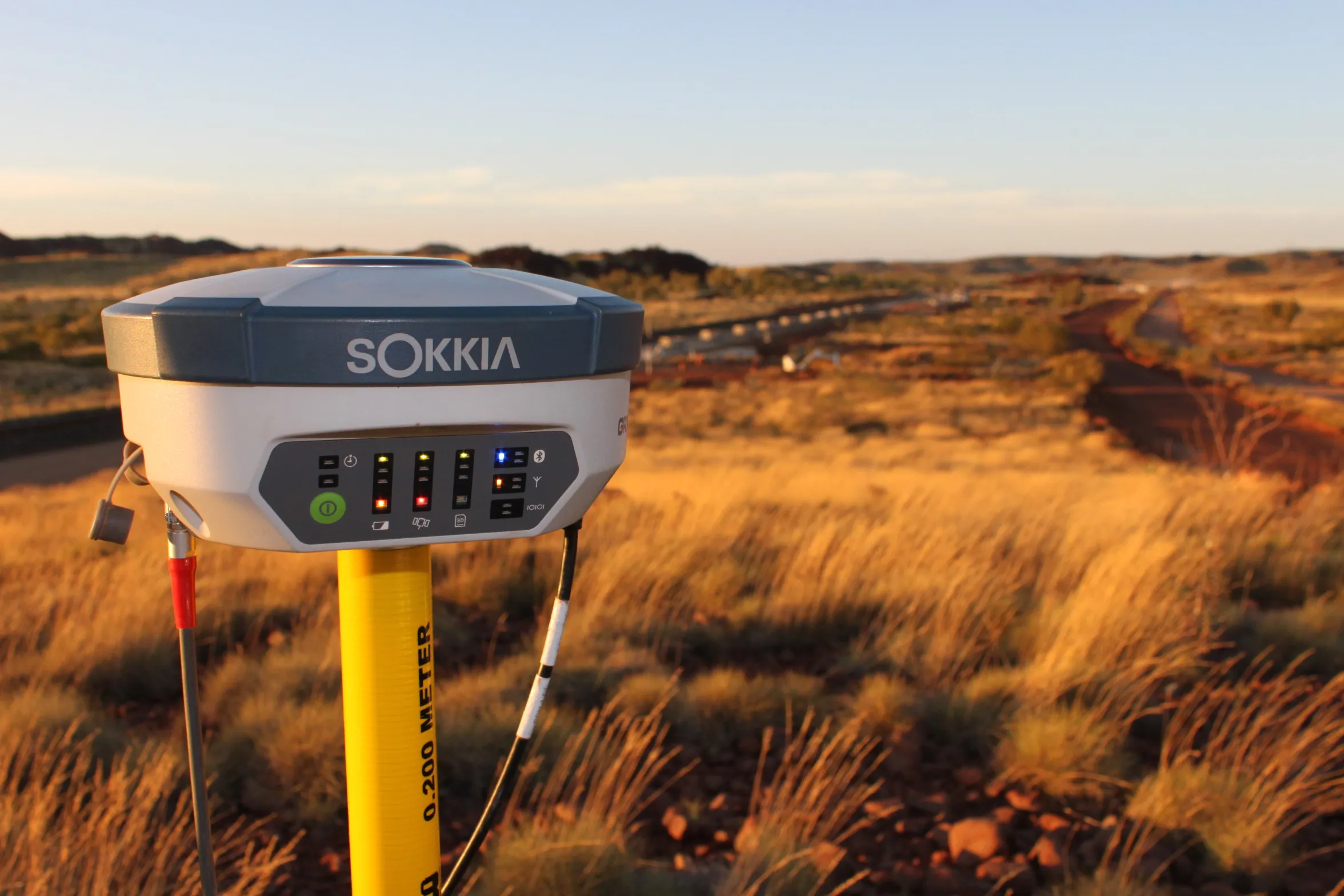
Real-time GNSS has turned positioning in surveying into a live, data-driven process rather than something that must always wait for later office checks. This allows coordinates, levels and quality checks to be assessed on site, which can reduce rework and help crews make faster decisions while conditions are still in front of them. For surveyors working on active construction, civil and infrastructure projects, it provides a more responsive way to manage accuracy and workflow.
Combined with automated field validation, GNSS equipment can now flag outliers, compare observations against design models and site control, and guide the surveyor through pre-set quality routines while work is underway. This is particularly useful on fast-moving projects where delays, missed checks or positioning issues can quickly affect downstream work.
Modern GNSS rovers connected to CORS networks or site-based stations can provide survey-grade centimetre-level positioning under suitable conditions. In practical terms, experts use this for:
Data is streamed straight to data collectors loaded with current design surfaces or alignment files. The surveyor can then see live deltas to design, cut and fill values and tolerance information while working. This allows immediate adjustments to pegs, batter lines or structure locations rather than waiting until calculations are checked back in the office.
Performance still depends on site conditions. Urban canyon effects, tree cover, multipath interference, poor satellite visibility and local obstructions can all reduce accuracy or reliability, which is why experienced surveyors still confirm whether GNSS is suitable for the task and when another method or additional checks are required.
Automated validation tools embedded in controllers and GNSS software now perform many of the traditional checks continuously. Typical automated processes include:
If a control point does not meet the configured thresholds, the system prompts for reoccupation or warns that a different setup is required. For construction set-out, the controller can also require independent check shots or backsight validation before allowing work to continue.
Validation tools are most effective when they are closely linked with office software. Surveyors push current design models, control databases and coordinate system definitions to field devices so checks happen against the latest available information. On return to the office, data can then flow directly into drafting and BIM or CAD environments with quality flags preserved.
This integrated approach shortens turnaround for deliverables, supports rapid clash and tolerance assessments and helps maintain stronger conformance records across subdivision, infrastructure and construction projects.
Drone surveying has become a practical tool for rapidly measuring large or complex sites that would be slow or unsafe to capture on foot. By combining survey-grade drones with automated flight planning and processing, surveyors can deliver accurate ground models, volumes and site checks far more efficiently than many traditional field methods. For project managers, engineers and developers, this supports quicker decisions based on current ground conditions and can help track progress across construction, bulk earthworks and infrastructure corridors. Drone operations used for surveying work must also comply with CASA requirements, including the applicable rules around drone registration, operator accreditation or licensing, and any permissions needed for the way and location in which the drone is flown.
On a typical project, professional surveyors define the survey area, required outputs and site constraints, then design an automated flight path that maintains suitable altitude, overlap and image quality for the intended survey purpose. This flight plan is uploaded to the drone so it can follow a controlled pattern aligned with the project’s accuracy and coverage requirements. Before flying, the team must also confirm that the operation complies with CASA rules and that the pilot, aircraft registration and operating conditions are appropriate for the job.
Ground control points or RTK/PPK positioning are then used to tie the drone data to the project datum and MGA coordinates, which is essential for engineering design and construction set-out. High-resolution imagery or LiDAR data can then be processed into point clouds, digital terrain models and orthophotos that align with the existing survey control network.
Drone surveys are particularly effective where traditional fieldwork is slow, risky or cost-prohibitive. Typical use cases include major greenfield subdivisions, quarries and landfills, linear infrastructure such as roads, pipelines and power corridors, and steep or vegetated terrain.
On bulk earthworks projects, frequent drone flights can measure stockpile volumes and cut-and-fill quantities using a consistent methodology. This supports contractor claims, cross-checks machine control data and helps clarify how much material has actually moved between programme milestones.
For coastal or flood-prone land, drones can provide a detailed surface model that can then be used alongside hydraulic or coastal engineering analysis. In remote regional areas, they can reduce the need for extended field mobilisation and allow more processing and quality control to be completed in the office.
Automated data capture does not stop when the drone lands. Processing workflows can be configured so each flight follows the same naming, control and quality procedures, with outputs delivered in formats that integrate more cleanly into CAD and GIS environments.
Successive drone datasets can be aligned so that change is quantified rather than estimated visually. Designers and project managers can compare stages, check compliance against design surfaces and identify areas where works are diverging from the plan.
For complex sites, drone data is often combined with traditional ground surveys to improve coverage in dense vegetation or around structures. This hybrid approach provides the efficiency of aerial capture while retaining the precision required at critical features such as building corners, utilities and cadastral boundaries.
3D laser scanning has become a core tool in Australian surveying projects because it captures millions of measurements in a matter of minutes. The result is a dense point cloud that accurately represents existing conditions across sites, structures and infrastructure. AI-assisted processing can then help turn that raw point cloud into usable information more efficiently, while standard automated workflows handle registration, cleaning, modelling and output formatting. For clients, this means quicker turnaround on surveys, more detailed deliverables and better information for design or construction decisions.
On typical projects, surveyors deploy terrestrial laser scanners or mobile scanners to capture the built and natural environment. The scanner records millions of XYZ points plus intensity and sometimes colour to create an accurate 3D snapshot.
In practical terms, this is applied to:
Control is tied into the survey datum using total stations or GNSS, so the point cloud fits seamlessly into local coordinate systems and project grid requirements. This is critical for design consultants and contractors who need confidence that the 3D data aligns with other survey and engineering information.
The challenge with laser scanning is not collecting data but processing it. Raw point clouds are large and complex, and manual classification is slow. Standard automation helps with registration, cleanup and repeatable processing steps, while AI-assisted tools can support classification and feature recognition by identifying patterns and geometries that correspond to real-world elements.
Using AI, professionals can:
This automation reduces manual clicking and tracing, lowering processing time and cost while improving consistency across large datasets.
AI-enabled point cloud processing enhances the range and quality of outputs that surveyors can deliver. Typical deliverables include:
On active construction sites, AI can support repeated scans to track progress, identify deviations early and reduce the risk of costly rework. For asset owners, high-quality 3D records provide a reliable baseline for maintenance planning, upgrades and future expansion with far less need for repeated site visits.
Building information modelling has become a common expectation on many major Australian construction and infrastructure projects, particularly where multiple consultants, contractors and asset owners need to work from shared digital information. For surveyors, this means combining precise field measurement with structured digital deliverables that can be used directly in design, coordination and construction workflows rather than treated as standalone survey outputs.
Automation and AI-assisted processing are changing how survey information is captured, structured and validated before it enters the BIM environment. The focus is on traceable coordinates, cleaner models and consistent data standards so survey outputs support faster design decisions and reduce the risk of on-site surprises. On larger coordinated projects, this can play an important role in improving communication between design, construction and asset management teams.
On many current projects, the starting point is still a detailed feature and level survey. The difference is that this information may now need to be delivered not only as 2D plans but also as 3D surfaces and objects that integrate into Revit, Civil 3D or other authoring platforms.
AI-supported processing of total station, GNSS and laser scan data allows surveyors to classify points into different features. Automated routines then generate terrain models, breaklines and building outlines that align with the project coordinate system and survey control. This reduces manual drafting time and gives designers a more reliable topographic model they can reference in their BIM files.
When required, surveyors can also produce simple BIM objects to represent surveyed structures such as retaining walls or existing buildings. These are positioned on accurate survey control so engineers and architects can coordinate their designs against current site conditions with greater confidence.
Reality capture is now a key part of BIM integration on larger or more complex projects. Using UAVs and terrestrial laser scanners, large areas or detailed structures can be captured in dense point clouds. AI tools help clean noise, register multiple scans and extract key geometry such as floor levels, façade planes and structural grids.
These cleaned point clouds and derived meshes are then supplied as:
During construction, survey-grade reality capture provides a faster way to check whether built work aligns with the coordinated BIM model. Automated comparison tools can highlight deviations between the as-designed model and the as-built point cloud. This helps identify set-out issues earlier, verify tolerances and generate more accurate as-built models for handover.
Survey deliverables still need to match the digital requirements of the specific project. On some jobs this may involve detailed BIM-ready outputs, while on others the focus may remain on 2D drawings, surfaces or coordination models rather than a full BIM workflow.
AI-assisted workflows can be configured to suit these requirements, whether that involves defined layers in DWG, model segregation for structures and services or metadata fields that support asset management.
File naming, coordinate systems, level of detail and attribute coding are typically agreed upfront so deliverables can move more cleanly into the project’s common data environment. This reduces rework by design consultants and improves traceability across design, construction and facilities management once the asset is in operation.
Automation and AI-assisted processing can speed up data capture, validation and office workflows. But in land surveying, these tools still sit under a strict legal and professional framework. Digital tools do not replace the accountability of a registered surveyor. In New South Wales, registered surveyors remain responsible for boundary definition, data integrity and compliance with applicable surveying and planning requirements. AI is best understood as a support tool that helps manage large datasets, apply consistent checks and improve workflow efficiency, while final legal and professional responsibility remains with the surveyor.
Automated systems can assist with identifying inconsistencies, maintaining clearer audit trails and reducing manual handling errors, but every cadastral decision and final survey outcome still requires human review and professional judgement. This is especially important on projects involving boundaries, title definition, control networks or any work that may later be subject to compliance, certification or legal scrutiny. In practice, automation strengthens the process, but it does not remove the need for expert oversight.
Cadastral and engineering surveys in New South Wales must comply with legislation such as the Surveying and Spatial Information Act 2002 (NSW) and the Surveying and Spatial Information Regulation, together with the applicable standards, directions and practice requirements that govern survey work. Automation can support compliance by embedding rule-based checks into processing workflows, while AI-assisted tools may help identify patterns, anomalies or incomplete datasets within larger bodies of survey information. For example, automated routines can flag missing connections, coordinate discrepancies, incomplete field records or observations that fall outside required tolerances before the final survey is reviewed.
Even with these tools, regulatory compliance still depends on professional judgement. A digital workflow may compare new observations against SCIMS or other control information and highlight anomalies, but the surveyor must decide whether the issue is acceptable, requires recollection or calls for a different interpretation of the available evidence. This ensures that automated outputs remain part of a professionally controlled process rather than replacing the legal and ethical responsibilities attached to surveying work in Australia.
No matter how advanced the technology, only a registered surveyor can certify a deposited plan or sign off on boundary work in Australia. Their role in an AI-enabled practice includes:
Automation and AI-assisted tools are treated as support systems that help speed up processing, improve consistency and highlight issues for review. The registered surveyor still interprets the evidence, applies the law and ensures that every final plan properly reflects title, boundary and statutory requirements. This professional oversight is what protects clients from boundary risk and keeps projects compliant.
Automation, digital workflows and selected AI-assisted processes are reshaping how survey firms plan, capture and deliver surveying work. For clients, this does not just mean faster fieldwork. It changes when decisions can be made, how clearly risks are understood and how confidently a project can move through approvals and construction.
For a firm, automation does not replace the surveyor. It shifts time away from manual tasks into checking, interpretation and client advice. The instruments and software do more of the measuring and modelling, so the survey team can focus on accuracy, compliance with standards and communicating what the data actually means for a project.
Modern robotic total stations, GNSS rovers and automated workflows in software reduce the number of site visits and the hours spent on repetitive processing. A setout that once required a crew all day may be completed in a few hours with a single surveyor and a robotic total station that tracks and records points automatically.
The practical result is shorter lead times for key deliverables such as:
Because data is captured digitally at the source and processed through consistent templates, the risk of transcription errors is reduced. Automation allows checks to be built into the workflow so discrepancies in levels or boundaries are flagged quickly, rather than being discovered late in construction when they are expensive to fix.
Automation also changes the type and density of information available. Drone photogrammetry, terrestrial laser scanning and automated coding in field controllers generate point clouds and surface models that are far more detailed than traditional spot-level surveys.
Designers can work with accurate ground surfaces, building faces and structures from the outset, improving earthworks estimates and clash detection. For example, architects and engineers can import survey models directly into BIM or CAD platforms instead of tracing or redrawing linework. This reduces rework and helps catch issues such as driveway gradients or retaining wall heights early in the design process.
For planning applications and subdivision work, automated processing of cadastral data and aerial imagery can help verify boundaries and improvements more efficiently. This supports clearer documentation for councils and service authorities.
Automation, digital workflows and AI-assisted processing are no longer distant concepts; they are reshaping how projects are scoped, delivered and managed today. From faster data capture with drones and mobile mapping to automated drafting, rule-based validation and AI-assisted point cloud processing, these tools help deliver surveys with greater speed, consistency and detail. They are also changing how projects are planned, coordinated and communicated. Yet the core of successful surveying remains the same: sound professional judgement, a deep understanding of local conditions and regulations and a commitment to service. The real value lies not in the technology alone, but in how it is applied within the practical realities of Australian construction, infrastructure and land development.