Fastest Turnaround Times In The Surveying Industry!


Our team at MCS Surveyors in Wollongong understands that land development and construction projects often come with unique challenges that require a balance of precision, expertise, and local knowledge. From dealing with complex topography to complying with strict regulatory requirements, every project demands careful planning and execution. Our team has spent years helping clients navigate these issues with practical solutions and advanced techniques, ensuring smoother approvals and faster project progress.
Understanding local terrain conditions, council regulations, environmental factors, and technological advancements is essential for achieving successful outcomes. Whether you're developing residential property, working on waterfront land, or managing large-scale infrastructure, our experience in overcoming these challenges allows us to deliver accurate, reliable, and efficient results. Below, we share valuable insights into how these obstacles can be managed effectively while ensuring compliance and precision at every stage.

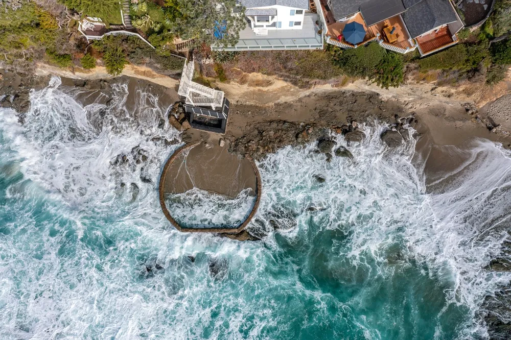
Developing properties on sloping blocks and waterfront land requires specialised strategies and careful planning. These sites often present unique structural, drainage, and environmental challenges that can complicate both design and approvals. Accurate measurements and detailed reporting are critical to creating workable solutions that maximise land use while maintaining safety and sustainability. With a thorough understanding of local conditions, we ensure each project moves forward with confidence and efficiency.
Delivering precise contour and detail surveys is essential for managing projects in areas with variable terrain. Our team uses a combination of traditional expertise and advanced technology to capture accurate data and generate reliable reports.
Understanding and complying with council regulations is one of the most significant challenges for any development project. From planning permits to zoning restrictions, each step requires careful consideration to avoid delays and additional costs. Our familiarity with local processes allows us to streamline approvals and provide clients with practical advice to meet all necessary standards. Working closely with stakeholders ensures smoother collaboration and more efficient outcomes.
Local councils prioritise long-term sustainability when approving development applications. It’s essential to design projects that align with environmental goals while also maximising land potential.

Wollongong’s varied landscape brings additional compliance considerations for developments near bushfire-prone zones and coastal areas. Meeting these requirements is essential to protect both property and the environment. Our team carefully assesses site risks and integrates appropriate measures to ensure adherence to local and state regulations. By managing these aspects early, we help clients avoid potential setbacks and achieve approvals faster.
Identifying hazards early enables projects to incorporate protective measures from the start. Our comprehensive assessments ensure long-term safety and compliance.
Delays in approvals or construction can significantly impact project timelines and budgets. To overcome this, efficient planning and coordination are key. By working closely with councils, engineers, and builders, we identify potential roadblocks early and streamline processes. Our approach focuses on removing unnecessary delays and helping clients achieve their project goals on time.
A structured approach to project management ensures smoother progression from planning to completion. Our experience allows us to guide clients through every stage seamlessly.
Advancements in technology have transformed the surveying industry, providing faster, more accurate, and cost-effective solutions. By adopting cutting-edge tools, we deliver exceptional results that enhance decision-making and project outcomes. These innovations allow us to tackle complex terrain and regulatory demands with greater confidence. Integrating technology into our workflows ensures clients benefit from precision and efficiency at every stage.
Modern tools and techniques improve both accuracy and speed in surveying. Our team uses technology to enhance data quality and simplify complex processes.
Successfully managing topographical and regulatory challenges requires experience, innovation, and a deep understanding of local requirements. MCS Surveyors combines advanced techniques with practical solutions to help clients navigate even the most complex projects. From sloping blocks and waterfront developments to regulatory approvals and compliance strategies, our expertise ensures accurate results and smoother outcomes.
By embracing technology, maintaining strong council relationships, and providing transparent client support, we deliver tailored solutions that keep projects moving forward. Whether it’s a residential development, commercial build, or large-scale infrastructure project, our goal is to simplify the process and achieve the best results for our clients.