Fastest Turnaround Times In The Surveying Industry!


Major developments place increasing demands on surrounding buildings, public spaces and underground infrastructure. As projects become larger, deeper and more complex, the potential for ground movement, structural deformation and changes in ground conditions also increases. This makes accurate survey monitoring an essential part of construction risk management. Rather than relying on assumptions or one-off inspections, monitoring provides objective, measurable evidence of how a site and its surrounding assets are performing throughout every stage of a project.
As trusted surveyors in Sydney, MCS Surveyors delivers precise monitoring solutions that help developers, engineers and contractors manage these risks with confidence. This article explains when survey monitoring becomes critical on major developments and why the timing, scope and quality of a monitoring programme are just as important as the technology used. It also explores how excavation depth, proximity to neighbouring buildings, transport corridors and existing infrastructure influence monitoring requirements and how reliable monitoring data supports design validation, regulatory compliance, contractor accountability and informed decision-making.
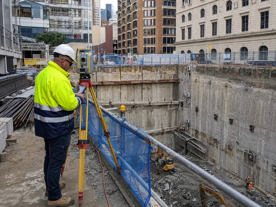
Construction monitoring surveys involve the ongoing measurement of the position, level or deformation of structures, ground and infrastructure. Using highly precise surveying techniques, it identifies even millimetre-level changes that may indicate developing issues long before they become visible or affect the safety and performance of a project.
Unlike a one-off boundary survey or construction set-out, survey monitoring establishes a series of measurements taken at regular intervals throughout a project's lifecycle. Comparing each set of observations with previous readings enables engineers and project teams to identify trends, verify that structural behaviour remains within design tolerances and maintain a reliable record of site performance for regulatory, engineering and legal purposes.
Major developments are rarely constructed in isolation. Excavation, piling and heavy construction often take place only metres from occupied buildings, transport infrastructure, underground utilities and other sensitive assets. Even where designs have been modelled, changes in ground conditions can influence surrounding structures, making continuous monitoring important throughout construction.
Rather than waiting for visible cracking, settlement or other signs of damage, survey monitoring provides objective data that shows how structures and the surrounding ground are responding in real time. This allows engineers to confirm whether conditions remain within acceptable design limits and respond quickly if unexpected changes begin to develop.
As urban areas become more densely developed, construction projects are increasingly undertaken alongside existing buildings, busy roads, rail corridors and ageing utility networks. Deep basement excavations, high-rise developments and major infrastructure works all have the potential to influence neighbouring assets if ground conditions change.
Accurate monitoring provides engineers with reliable information about how nearby structures are responding throughout construction. If results indicate that displacement or deformation is approaching predetermined trigger levels, construction methods, excavation sequences or temporary support systems can be reviewed before more significant problems occur.
Many major developments are required to implement survey monitoring as part of development consent conditions, engineering specifications or asset protection agreements. Local councils, transport authorities, utility providers and project stakeholders frequently require documented monitoring programmes wherever construction activities could affect adjoining infrastructure or neighbouring properties.
Maintaining consistent monitoring records demonstrates that observations have been collected throughout the project using recognised surveying procedures. These records provide valuable evidence that engineering requirements, approval conditions and asset protection obligations have been satisfied, while also supporting inspections, compliance reporting and project close-out documentation.
Construction projects involve numerous stakeholders. When concerns arise about structural damage or changing ground conditions, reliable survey monitoring provides an independent record of what has actually occurred rather than relying solely on visual inspections or differing opinions.
By comparing current observations against established baseline measurements, project teams can determine when changes began, how they have progressed and whether they remain within acceptable engineering limits. This objective evidence improves transparency, supports faster decision-making and helps minimise costly delays, insurance claims and disputes by providing a clear record of site behaviour throughout construction.
Survey monitoring is required whenever construction activities have the potential to affect surrounding structures, public infrastructure or ground conditions. While it is most associated with large-scale developments, monitoring may also be specified for smaller projects where the site is close to sensitive buildings, transport infrastructure or underground services.
Understanding the broader surveying services required for construction projects can help project teams coordinate monitoring with set-out, control, as-built documentation and other surveying requirements.
Whether a monitoring programme is required is determined through a combination of engineering risk assessments, development consent conditions and the proximity of existing assets. On many higher-risk projects, monitoring forms part of the project's approval requirements and remains in place throughout key stages of construction.
Deep excavations present some of the greatest risks to surrounding ground conditions. Multi-level basements, cuttings in sandstone and excavations through variable fill can all influence nearby structures if not carefully managed.
Project teams should also review the applicable excavation safety requirements before commencing deep excavation, shoring or earthmoving activities.
Survey monitoring is commonly required for projects involving:
Developments with deep basements located close to neighbouring property boundaries are likely to require ongoing monitoring. This is common in densely developed areas such as Sydney CBD, Chatswood, Parramatta and other major commercial or transport precincts where excavation activities occur close to existing buildings and public assets.
Projects constructed adjacent to older or more vulnerable buildings often require deformation monitoring to protect structures that may already be susceptible to settlement or vibration. This commonly includes:
Throughout excavation, piling and structural works, survey monitoring tracks changes in position and elevation at selected points on these buildings. The resulting data enables engineers to confirm that structural behaviour remains within acceptable limits and provides objective evidence.
Developments located near transport infrastructure or essential services are subject to strict monitoring requirements. Construction activities close to these assets must demonstrate that surrounding infrastructure continues to perform safely throughout the project. Before ground-disturbing work begins, current utility plans should also be requested through Before You Dig Australia to help identify underground infrastructure within and around the site.
Transport authorities, utility providers and asset owners require monitoring as part of protection or interface agreements. Monitoring targets may be installed on rail infrastructure, retaining structures, culverts, utility access points and other critical assets so that any change in position can be identified quickly and assessed against agreed performance criteria.
High-rise developments, mixed-use precincts and staged urban renewal projects often require monitoring because of the loads they place on foundations and surrounding ground.
Several factors increase the need for monitoring, including:
Selecting appropriate surveying technologies for large-scale developments can improve measurement accuracy, data sharing and coordination between surveyors, engineers and construction teams.
Monitoring often begins before excavation and continues through structural completion and stabilisation. Tracking long-term trends allows engineers to verify that settlement, tilt and structural behaviour remain consistent with the assumptions made during geotechnical analysis and structural design.
Excavation, piling, tunnelling and new structural loads can influence the behaviour of surrounding ground and nearby assets. Many of these changes develop gradually and may not become visible until cracking, distortion or other damage has already occurred. Survey monitoring enables project teams to identify these changes at an early stage, allowing construction methods or engineering controls to be adjusted before risks escalate.
Using high-precision instruments, surveyors can detect positional changes as small as a fraction of a millimetre. This level of accuracy provides valuable insight into how buildings, retaining structures, transport infrastructure, utilities and the surrounding ground are responding throughout construction.
The most common types of change that monitoring identifies are:
Together, these observations provide a comprehensive picture of how a site is responding throughout construction. Rather than relying solely on visual inspections, engineers can assess trends, compare results against established trigger levels and make decisions based on objective survey data.
Monitoring should begin before excavation or structural works start and continue until the ground and nearby structures have clearly stabilised. Starting too late or finishing too early is one of the most common causes of disputes about damage and responsibility.
The ideal programme spans three clear phases: a pre-construction baseline period, active-construction monitoring and a post-construction stabilisation period. The specific timing and duration depend on the site conditions, construction method and adjacent risk.
Monitoring should commence once the design and construction methodology are settled but before any intrusive work begins. This is critical for establishing a reliable baseline against which all subsequent movement is compared. This usually means:
Baseline monitoring often begins several weeks before demolition or excavation. Early start is important where consent conditions or local council asset protection requirements apply.
Monitoring should be most intensive during the highest-risk stages of construction. These include:
During these phases, monitoring frequencies often range from weekly to daily readings. For very sensitive assets or when trigger levels are approached, automatic or near real-time systems may be required.
Consent conditions, project insurance and third-party agreements frequently specify minimum monitoring intervals and thresholds. These requirements should be reviewed so that the programme remains compliant throughout construction.
Monitoring should not stop the day structural works are complete. Soil and structures often continue to adjust as loads redistribute and moisture conditions recover.
A typical stabilisation period ranges from 3 to 12 months after completion of major structural works or after final de-propping of excavation support. The length depends on:
Monitoring can usually cease once several consecutive rounds of readings show negligible movement, with trends indicating stability and all values comfortably within agreed performance criteria.
Survey monitoring relies on specialised instruments capable of detecting extremely small changes in position, elevation and structural behaviour over time. The equipment selected depends on the type of project, the required level of accuracy and whether monitoring is undertaken manually at scheduled intervals or through continuous automated systems.
Rather than relying on a single instrument, most major developments use a combination of monitoring technologies. Each tool measures different aspects of movement, allowing surveyors to build a complete picture of how structures and surrounding ground are behaving throughout construction. When multiple instruments confirm the same trends, engineers can decide confidently.
Robotic total stations form the backbone of most survey monitoring programmes. These instruments measure the precise horizontal and vertical position of monitoring prisms installed on buildings, retaining walls, bridges, rail infrastructure and other assets that could be affected by construction activity.
Because total stations observe the same targets with exceptional precision, they are ideal for tracking settlement, lateral movement and structural displacement over extended periods. On higher-risk developments, automated total stations can collect readings at predetermined intervals throughout the day without requiring a surveyor to be present on site. This provides near real-time movement data that enables engineers to respond quickly if unexpected changes occur.
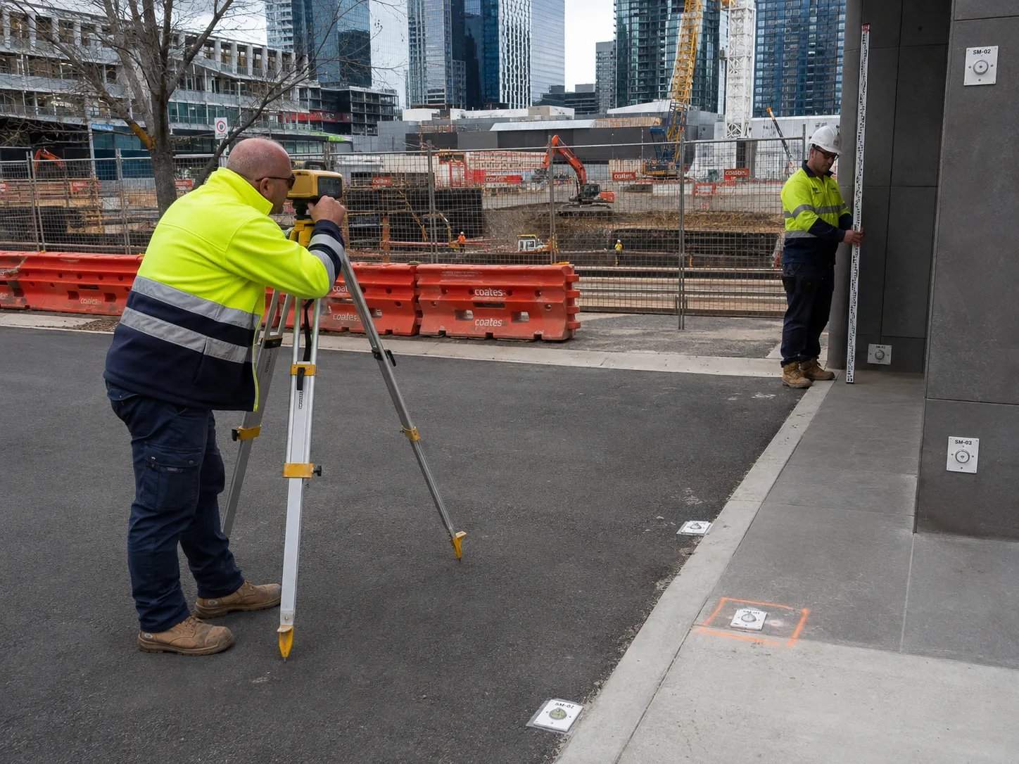
Where highly accurate elevation measurements are required, digital levels are used to monitor settlement of buildings, pavements, retaining structures and surrounding ground. Their repeatability makes them effective for identifying gradual vertical movement that may develop over weeks or months.
GNSS (Global Navigation Satellite System) receivers are also used where appropriate on large infrastructure projects or expansive sites where long observation distances make satellite positioning more practical. While GNSS does not provide the same level of vertical precision as digital levelling, it delivers reliable three-dimensional positioning and is well suited to monitoring across larger project areas.
Projects with elevated construction risks or strict regulatory obligations often incorporate automated monitoring systems that continuously record movement between scheduled survey inspections. These systems provide continuous oversight and can issue alerts whenever predefined trigger levels are exceeded.
Depending on the project, automated monitoring may include:
Data from these sensors is commonly integrated into central monitoring software alongside survey observations, allowing engineers to review multiple sources of information in one coordinated system.
Accurate monitoring depends as much on stable reference points as it does on sophisticated instruments. Prisms, survey marks, settlement bolts, wall targets and ground pins are installed on structures and surrounding areas to create fixed locations that can be measured consistently throughout construction.
A stable survey control network is established outside the area expected to experience movement, providing a permanent reference against which all future observations are compared. By maintaining this consistent framework, surveyors can confidently distinguish genuine structural movement from normal variations caused by instrument setup or environmental conditions.
Collecting monitoring data is only one part of the process. To identify movement, every observation must be gathered using consistent methods and compared against a stable reference framework. This repeatability allows surveyors to distinguish genuine structural or ground movement from normal measurement variation.
A well-designed monitoring programme follows a structured workflow, ensuring each set of readings can be directly compared with previous observations to identify trends, verify design assumptions and determine whether movement remains within acceptable engineering limits.
Every monitoring begins by establishing a permanent survey control network outside the expected zone of influence of excavation or construction activity. Control marks are installed in stable locations such as concrete structures or rock so they remain unaffected throughout the project.
These control points are coordinated using recognised datums, such as MGA for horizontal position and AHD for elevation. Monitoring targets are then installed on the structures or ground expected to move, including retaining walls, adjacent buildings, pavements, excavation support systems and other critical assets.
Each monitoring point receives an initial set of coordinates or levels that forms the project's baseline dataset. All future observations are compared against this baseline to determine whether movement has occurred.
During each monitoring round, surveyors return to the same control network and measure every monitoring target using consistent procedures. Maintaining similar instrument setups, observation geometry and environmental conditions helps minimise the influence of external factors such as temperature or atmospheric refraction.
Depending on the project, monitoring may be undertaken manually at scheduled intervals or automatically using robotic total stations and integrated sensor systems. Automated installations are valuable for high-risk projects because they can capture frequent observations throughout the day while providing rapid notification if movement exceeds predefined thresholds.
After each monitoring round, the new measurements are processed and adjusted against the established control framework. This ensures any calculated movement reflects genuine changes rather than minor differences in instrument setup or observation conditions.
For every monitoring point, surveyors calculate:
These results are then assessed against trigger levels established by the project's engineers. Many programmes adopt a tiered response system, with lower-level alerts prompting increased observation and higher-level thresholds requiring engineering review or construction changes.
The true value of survey monitoring lies in how the collected data is applied. Rather than simply recording movement, monitoring provides engineers and construction teams with objective information that supports timely decisions throughout every stage of a project.
By identifying movement trends early and comparing them against established engineering limits, monitoring helps minimise structural risks, maintain regulatory compliance and reduce the likelihood of costly project delays or disputes.
Before construction begins, engineers establish movement thresholds for critical structures and infrastructure. These trigger levels define the amount of acceptable movement and determine the actions required if observations exceed expected limits. Monitoring data is continually assessed against these thresholds, allowing project teams to:
This structured response process enables issues to be addressed proactively instead of reactively.
Survey monitoring also provides valuable feedback on how structures are responding to construction activities compared with original design assumptions. By reviewing movement trends, engineers can determine whether excavation support systems, retaining structures and foundation designs are performing as intended. Where necessary, monitoring results may support decisions to:
Using measured performance rather than assumptions allows engineering decisions to be based on objective site conditions.
Monitoring is also important in protecting neighbouring buildings, public infrastructure and underground services throughout construction. Accurate records provide independent evidence that movement has remained within agreed limits and demonstrate that the project has met its monitoring obligations. Comprehensive monitoring data also assists with:
For major developments, these documented records often become an important part of the project's overall risk management strategy.
Survey monitoring is only as reliable as the expertise behind it. Even the most advanced equipment cannot produce meaningful results without careful planning, consistent field procedures and experienced interpretation. Accurate monitoring requires more than collecting measurements; it requires understanding how construction activities, ground conditions and structural behaviour interact throughout the life of a project.
Experienced surveyors develop monitoring programmes that reflect the specific risks of each site rather than applying a standard approach. This includes selecting appropriate monitoring locations, establishing stable survey control, determining suitable observation frequencies and coordinating closely with engineers, contractors and asset owners from the earliest stages of construction.
For projects involving deep excavations, transport infrastructure, utilities or neighbouring buildings, surveyors also understand the regulatory requirements and reporting standards expected by councils, government authorities and other stakeholders. Their ability to provide accurate, repeatable and well-documented monitoring data helps reduce uncertainty and supports informed engineering decisions.
As developments become larger and more technically demanding, survey monitoring remains one of the most effective ways to manage construction risk. By detecting movement early, validating engineering assumptions and providing objective evidence throughout construction, monitoring helps protect surrounding assets, supports regulatory compliance and enables informed decision-making before small issues become costly problems.
For developers, contractors and asset owners, partnering with an experienced surveying specialist is essential to achieving reliable monitoring outcomes. MCS Surveyors delivers accurate, dependable survey monitoring programmes tailored to each project's requirements, helping clients minimise risk, satisfy compliance obligations and keep major developments progressing safely from commencement through to completion.