Fastest Turnaround Times In The Surveying Industry!


The surveying profession is undergoing a profound transformation as technology, regulation and environmental pressures reshape how land is measured, documented and protected. For property developers, councils and infrastructure planners working with surveyors in Shellharbour, accuracy is no longer the sole expectation; surveying must now balance speed, regulatory certainty and environmental responsibility. At MCS Surveyors, we see this shift every day, with clients increasingly relying on modern, technology-enabled survey workflows to support responsible land development. From drone-enabled data capture to climate-resilient site assessments, modern surveying sits at the intersection of precision, compliance and sustainability.

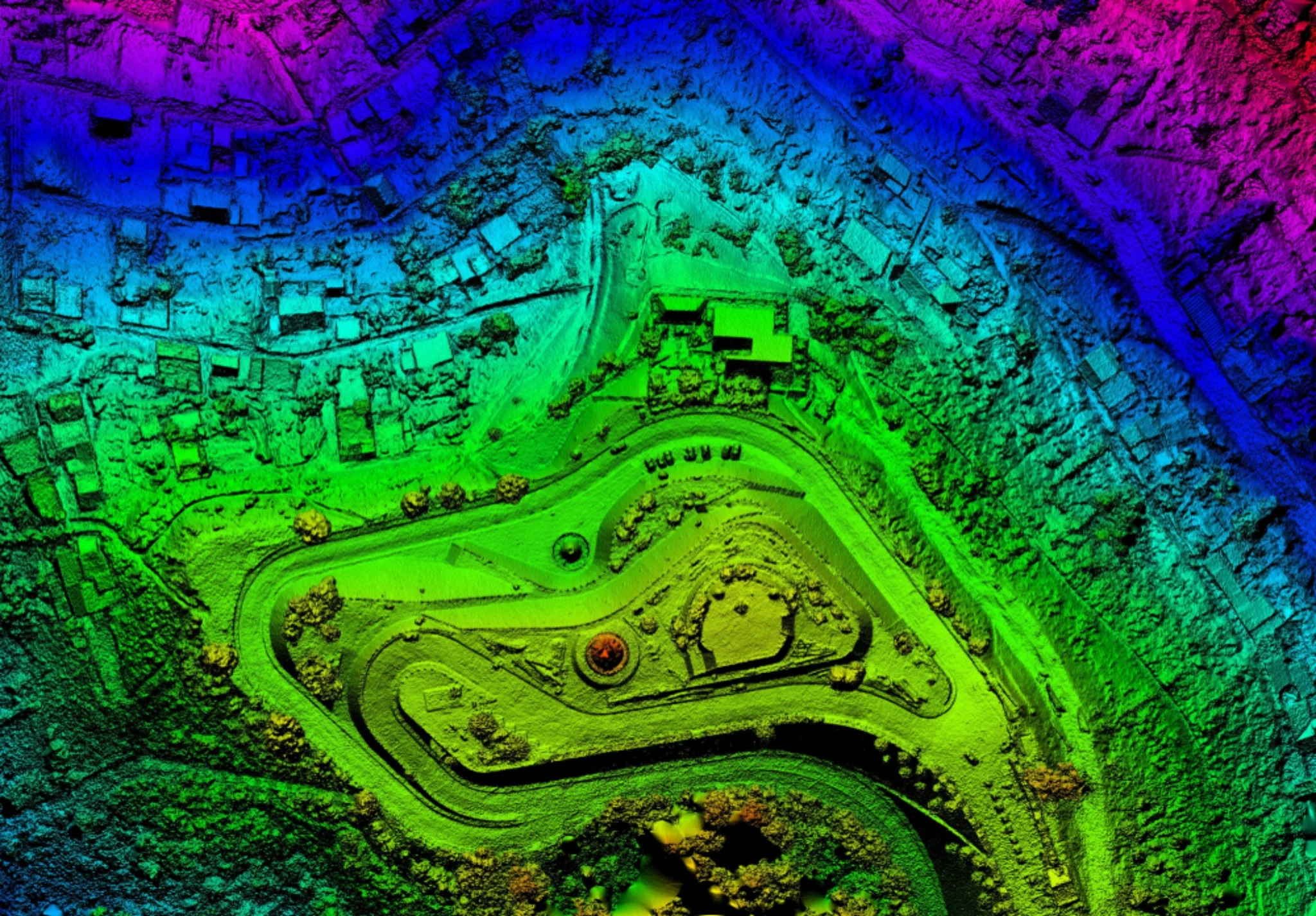
The way survey data is captured has changed dramatically in recent years, especially on large, complex or environmentally sensitive sites. Drones, LiDAR and satellite technologies allow surveyors to collect vast quantities of high-resolution spatial data with minimal ground disturbance, improving safety, accuracy and project timelines. These tools are no longer experimental; they are now integral to modern surveying practice in NSW.
In NSW land development, delays and uncertainty quickly translate into cost, risk and frustration. Delays caused by inaccessible terrain, safety constraints or repeated site visits can impact project feasibility. Drone and LiDAR surveying addresses these challenges by allowing rapid data collection across entire sites in a single deployment. For developers, these gains translate into fewer surprises and more predictable project timelines. Efficiency benefits include:
Some sites are simply difficult to survey using traditional methods. LiDAR, in particular, can penetrate vegetation to accurately model ground surfaces, making it invaluable for bushland, escarpments and floodplains common across NSW. Accurate terrain models also strengthen confidence during council review and certification stages. This improved accuracy supports:
Traditional surveying can be physically demanding on a site, especially where vegetation, soil stability or sensitive habitats are involved. Drone-based surveys significantly reduce this impact by limiting the need for ground penetration and repeated site visits. These benefits align surveying outcomes with broader sustainability objectives from the earliest project stages. Environmental advantages include:
Surveying in NSW operates within an increasingly complex regulatory environment, where compliance expectations now extend beyond boundary accuracy to include defensible, auditable survey records. Regulatory bodies now expect survey documentation to be structured, auditable and suitable for long-term governance. Digital compliance is not simply an administrative requirement; it is becoming central to risk management and professional accountability within the surveying industry.
Planning approvals in NSW now place much closer scrutiny on survey information than they once did. Surveyors must now ensure that data supports not only design but also environmental assessment, flood planning and infrastructure coordination. Survey data must withstand review across multiple approval pathways. Modern survey obligations have these:
Across NSW, councils and state agencies are transitioning fully to digital lodgement platforms, placing greater responsibility on surveyors to deliver clean, structured datasets. Surveyors are now responsible for delivering clean, structured datasets that integrate seamlessly into digital approval platforms. Poor digital hygiene can delay approvals and expose projects to compliance risk. Effective digital compliance relies on:
When survey data informs legal boundaries, approvals or infrastructure delivery, clear documentation becomes a critical risk-control measure. Digital workflows make it easier to trace decisions, verify data sources and demonstrate due diligence. Strong documentation practices help:
As surveying becomes more data-intensive, the way survey data is handled after capture increasingly determines its reliability downstream. Poor data management can undermine even the most precise fieldwork, leading to errors, misinterpretations and costly downstream impacts. Modern surveying requires disciplined data governance frameworks that protect data integrity across the entire project lifecycle.
Survey data now flows through multiple platforms, from field devices to processing software, BIM environments and client portals. Each transition introduces potential risks if not managed carefully. The controls ensure that final deliverables accurately reflect site conditions. Best-practice workflows focus on:
With multiple stakeholders relying on survey data, version control is critical. Surveyors must be able to demonstrate which dataset is current, who approved it and how it has evolved. An effective audit trail supports these factors:
Surveying conditions are becoming more challenging as flooding, bushfires and extreme weather events occur more frequently. Surveyors play an important role in helping clients understand and respond to these risks through accurate, context-aware site data. Surveying is no longer a static snapshot; it must reflect dynamic environmental conditions.
As climate patterns shift and extreme rainfall events become more frequent, flood risk is no longer a fringe consideration; it is a core design constraint. Flood-prone areas require highly detailed and reliable elevation data to support accurate flood modelling, planning approvals and long-term site resilience. Even small discrepancies in level data can alter flood extents, flow paths and finished floor requirements, leading to design revisions, compliance issues or increased construction costs. Survey contributions include:
In bushfire-prone zones, surveying extends well beyond boundary definition and topographic mapping. As development pushes into interface areas between bushland and urban land, accurate survey data becomes essential for managing risk to life, property and infrastructure. Survey information directly informs how sites are accessed, how buildings are positioned and how vegetation is managed in accordance with bushfire planning controls. Surveyors assist by:
Extreme weather conditions affect not only the land being surveyed but also how survey work is planned and executed. Flooded sites, saturated ground, high temperatures, smoke and restricted access can disrupt traditional field methods and pose safety risks. In response, modern surveying increasingly relies on flexible methodologies, remote sensing technologies and adaptive field planning to maintain accuracy and continuity of data collection.
Automation and AI are changing how surveying work gets done, but the biggest shift isn’t just about speed. Rather than replacing professional surveyors, these technologies are redefining where expertise is applied and where value is created. Routine, time-intensive processing tasks are increasingly automated, allowing surveyors to step back from raw data handling and focus on interpretation, coordination and risk management.
AI-assisted data processing is transforming how large and complex datasets are handled. Modern survey projects often generate massive volumes of information from LiDAR scans, drones and mobile mapping systems. Processing this data manually can be time-consuming and prone to inconsistency. AI-powered software now supports surveyors by rapidly analysing point clouds, identifying features and flagging anomalies that require professional review. Benefits are:
While automation improves productivity, it does not remove responsibility. Survey data underpins high-stakes decisions relating to safety, compliance and long-term asset performance. For this reason, professional oversight remains essential at every stage of the workflow. Automated outputs must be validated, reviewed and interpreted by qualified surveyors who understand the implications of errors, assumptions or data gaps.
As surveying tools and methodologies evolve, so too must the skills of the professionals using them. Continuous professional development is no longer optional because it is essential to maintaining competence, credibility and relevance. Surveyors must stay current with new software platforms, data standards, automation tools and regulatory expectations to operate effectively in a digital-first environment. Upskilling is not just about learning how to use new technology. It also involves understanding how digital tools affect risk, data governance and decision-making across project teams.
Surveyors are often seen as purely technical specialists, but their influence on sustainability starts much earlier than many people realise. The way land is measured, interpreted and documented directly affects how efficiently it can be developed and how much impact a project has on its surrounding environment. Responsible surveying supports smarter land use decisions by providing accurate, contextual data that helps project teams work with natural site conditions rather than forcing unnecessary intervention.
Traditional surveying methods often involved multiple site visits, duplicated data collection and manual rework when information was incomplete or misaligned. Modern digital tools allow surveyors to plan more efficiently, capture more complete datasets in fewer visits and share information seamlessly across project teams. By reducing unnecessary travel, minimising rework and improving coordination, smarter surveying workflows help lower the carbon footprint of development projects.
Accurate and well-interpreted survey data are foundational to sustainable design. This enables buildings, roads and infrastructure to be positioned in ways that minimise cut and fill, reduce material use and protect natural features. Surveyors support sustainable design by providing reliable base data that encourages adaptive solutions, ultimately reducing environmental impact while improving long-term performance.
Modern surveying sits at the intersection of innovation and stewardship. Reliable survey data now underpins safe approvals, resilient design and long-term community outcomes, sustainable planning and long-term community safety. Surveyors who embrace digital workflows, governance and environmentally responsible methodologies are best positioned to support the evolving built environment today and well into the future. If you’re planning a development, subdivision or infrastructure project and need surveying expertise that combines advanced technology with environmental responsibility, MCS Surveyors can help. Our team delivers precise, compliant and future-ready surveying solutions.