Fastest Turnaround Times In The Surveying Industry!


Before construction begins, more than architectural drawings and council approvals are needed. Accurate site data from qualified surveyors in Wollongong helps reduce the risk of boundary disputes, design errors, delays and compliance issues involving Wollongong City Council and other authorities.
This article outlines the key surveys commonly required before building. Each survey type supports a different stage of the project, from early design and development applications through to construction planning and final certification. It also explains Wollongong-specific considerations that can affect planning, design and compliance, helping property owners and project teams understand how surveys fit into the broader building process.
Choosing the right survey before building work begins is not just a procedural step. It directly affects design accuracy, council approval, construction cost and ongoing compliance with New South Wales requirements. The right survey identifies site constraints early, allowing architects, builders and certifiers to make informed decisions rather than relying on assumptions.
In Wollongong, this is especially important because sites often involve coastal conditions, sloping land, older boundaries and infill development. Accurate survey information helps confirm whether a design suits the land, complies with council controls and can be built safely and practically.
Architectural plans prepared without a current and detailed survey are far more likely to run into problems. If boundary positions, easements, levels or existing structures are wrong or missing, the design may need to be revised after submission to council or a certifier. That often leads to extra consultant fees, approval delays and changes to the building footprint, height or site layout.
A detailed feature and level survey at the beginning of the project helps avoid these issues. Reliable contours and spot levels allow finished floor levels, driveway grades and drainage outcomes to be designed properly. Accurate boundary information also reduces the risk of building over neighbouring land, easements or council assets.
Wollongong City Council and private certifiers rely on accurate survey information when assessing development applications and construction certificates. Survey data helps verify setbacks, building height, site coverage, easements and other site constraints that affect whether a proposal can proceed.
In New South Wales, cadastral or boundary surveying must be carried out by a registered surveyor. Informal plans or outdated site information can misrepresent the legal boundary and create problems during design, approval or construction. For projects involving strata, dual occupancies or changes to title boundaries, precise survey work is essential so that registration documents align with legal and physical site conditions.
Wollongong includes areas affected by steep topography, overland stormwater flow, coastal exposure and site-specific planning controls. A suitable pre-build survey gives planners, engineers and designers the information they need to assess these risks properly.
This may include land slope that influences footing and retaining wall design, drainage paths that affect floor levels and stormwater management, or proximity to waterways and the coast that may trigger additional controls. A thorough site survey can also record trees, retaining walls, fences, neighbouring structures and overlooking points, all of which may influence privacy, overshadowing and design compliance in built-up suburbs.
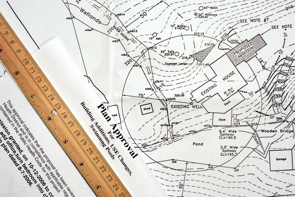
Most building projects begin with a detail and contour survey, sometimes referred to as a feature and level survey. This is the base survey used by architects, engineers, planners and certifiers to understand what exists on the site before design work progresses.
Without an accurate detail and contour survey, it is difficult to design confidently or assess whether a proposal is likely to comply with relevant planning controls. It provides the foundation for early design decisions and approval documentation.
A detail and contour survey records the site in three dimensions and shows the physical features that may affect design and construction. In Wollongong, this commonly includes:
This survey is generally supplied in PDF and CAD format so it can be used directly by designers and engineers as the base for project documentation.
A recent detail and contour survey is commonly needed for new dwellings, major additions, dual occupancies, secondary dwellings and many other forms of development in Wollongong. It supports decisions about building height, drainage, site access, privacy, overshadowing and compliance with setbacks and easements.
On sloping or irregular land, accurate levels are particularly important. Even minor errors can affect cut and fill calculations, retaining wall heights, driveway gradients and roof levels, potentially leading to redesign or approval issues later in the process.
A detail and contour survey should usually be arranged before any design work starts. In many projects, it is the first technical document requested by an architect or building designer because it allows them to position the building correctly and assess key constraints from the outset.
In most residential cases, one survey at the beginning is sufficient. However, if the project is delayed for a long period or the site changes significantly through demolition, filling or earthworks, an updated survey may be needed before approval or construction proceeds.
A boundary survey may be required in addition to a detail and contour survey when there is any uncertainty about the legal boundary. This is particularly important on older lots or infill sites where fences, retaining walls and driveways do not necessarily match the title boundary.
Clarifying the boundary before building reduces the risk of encroachment, neighbour disputes and costly redesign. It also gives builders and designers greater confidence when structures are proposed close to the property edge.
Any proposal that places new work near a front, side or rear boundary should raise the question of whether a boundary survey is needed. This commonly applies to:
Where setbacks are tight, accurate boundary definition is essential. It allows the legal boundary to be identified on site so that footings, walls and other elements can be set out correctly.
Boundary surveys are also important where the legal use or layout of land is changing. For strata subdivision, Torrens subdivision or boundary adjustments, accurate survey definition is necessary because new title plans must be created and registered.
Even where subdivision is not involved, a boundary survey may still be prudent if survey marks are missing, title dimensions do not appear to match the site, or proposed works could affect easements or title restrictions. Early clarification can prevent objections, redesign and approval complications later.
While most projects start with a detail and contour survey and sometimes a boundary survey, some sites require additional survey work because of planning controls, engineering requirements or the nature of the development.
These surveys are not required on every project, but identifying them early can help avoid delays, redesign and compliance issues as the build progresses.
Once approvals are in place and construction is ready to begin, a set-out survey may be needed so the builder can position footings, walls and structural elements in the approved location. This is especially important on constrained sites where there is little tolerance for error.
A set-out survey helps ensure the building is placed correctly relative to boundaries, easements and approved levels. It reduces the risk of encroachments and costly mistakes during construction.
.webp)
As-built or work-as-executed surveys record the final position and level of completed works. These surveys are usually carried out during or after construction, but it is often important to understand early in the project whether they will be required as part of the approval process.
For example, some developments require final verification of stormwater infrastructure, driveway levels, retaining walls or building position before occupation or sign-off. Knowing this in advance helps ensure the necessary survey control and access are considered during design and construction.
Where a project involves shared drainage, access or services across property boundaries, additional survey work may be needed to support easements or title changes. This is common in duplex, multi-dwelling, mixed-use and subdivision projects.
Reviewing these requirements at concept stage is important. A design may appear to comply with planning controls, but still create problems once legal boundaries, access corridors or common property arrangements are applied.
On steep sites, near excavations or in areas where neighbouring assets may be affected, monitoring surveys may be needed to track movement over time. These are generally specified by structural or geotechnical engineers where there is a risk to adjoining buildings, retaining walls or public infrastructure.
Dilapidation documentation is also often coordinated alongside survey information to create a reliable pre-construction record of nearby structures, roads and assets. Linking that record to surveyed reference points makes it easier to assess claims of damage and demonstrate whether any movement has occurred during the works.
The right survey depends on what is being built, where it is being built and what decisions need to be made at each stage of the project. The goal is to match the survey scope to the needs of the designer, certifier, engineer and builder so the project can proceed with accurate information.
In most cases, that starts with reviewing the proposal against Wollongong planning controls and the NSW planning framework, then confirming what consultants need in order to prepare compliant documentation.
The larger or more complex the project, the more detailed the survey requirements tend to be. A new dwelling, major extension or dual occupancy will usually require a full detail and contour survey as the base for design, drainage and approval work.
By contrast, a minor structure such as a small deck or carport may only require a more limited site survey if boundaries are clear and the work does not raise setback, drainage or height issues. Even then, assumptions should be avoided where legal boundaries or site levels are uncertain.
Survey requirements also change as the project moves forward. At the beginning, the main need is usually accurate site information for design and planning approval. Before construction starts, set-out surveys may be required so the builder can locate the approved works correctly on site.
Closer to completion, an as-built, identification or subdivision-related survey may be needed for certification, lending, registration or final authority sign-off. Thinking about this sequence early helps avoid gaps in documentation later.
Many approval delays and avoidable costs stem from survey mistakes made before plans are lodged or work begins. These problems often come down to incomplete information, incorrect assumptions or ordering the wrong survey scope.
Understanding the most common mistakes can help property owners and project teams avoid redesign, neighbour disputes and compliance issues.
One of the most common mistakes is relying on an old survey or using online mapping as though it reflects current site conditions. A survey that is several years old may not show new fences, retaining walls, structures, changed surface levels or altered neighbouring conditions that now affect privacy, overshadowing or access.
In areas with slope or drainage constraints, even relatively small changes in levels can affect building height calculations, stormwater design and driveway grading. Designing from outdated information often leads to corrections later, when the cost of change is higher.
Another frequent mistake is treating existing fences as though they mark the legal boundary. On many older Wollongong sites, that is not necessarily the case. Building to an assumed fence line without a proper boundary survey can lead to encroachment over neighbouring land or council property.
Title constraints can also be missed if plans are prepared without properly reviewing easements, rights of carriageway, drainage restrictions or other limitations affecting how the land can be used. Accurate survey work helps relate these legal constraints to what is physically on the site.
A further issue is requesting a generic survey without confirming what the architect, engineer, certifier or council will actually need. A simple contour plan may not be enough if the site involves subdivision, excavation near boundaries, easement creation, coastal controls or other complications.
Where the survey scope is too limited, additional work is often required later, which slows the project and increases cost. Defining the required survey output clearly from the beginning helps avoid duplication and delays.
Choosing the right survey before building is a critical step in delivering an accurate, compliant and well-planned project. From detail and contour surveys through to boundary definition, construction set-out and final verification, each stage relies on current and reliable site information.
In Wollongong, where sloping land, coastal influences, infill development and site-specific controls can all affect the approval and construction process, professional surveying provides the certainty needed to design properly and build with confidence. Rather than being an optional extra, it is a practical foundation for avoiding errors, protecting legal boundaries and supporting smoother project delivery from start to finish.