Fastest Turnaround Times In The Surveying Industry!


An accurate understanding of the seabed is essential for coastal developments. Whether planning a marina, harbour upgrade, pipeline installation or coastal protection works, seabed depth and shape influence safety, design feasibility and regulatory compliance. MCS Surveyors, trusted surveyors in Wollongong, understand that bathymetric surveys provide the reliable underwater data needed for informed project decisions.
Understanding when a bathymetric survey is needed helps project owners avoid unnecessary costs while reducing risk. Factors like changing seabed conditions, tidal movement, sediment transport and regulatory requirements influence the need for updated survey data. Knowing when to commission a survey ensures coastal works are planned with accurate information, supporting safer designs, smoother approvals and better outcomes.
Bathymetric surveying is the measurement and mapping of underwater terrain to determine the depth and shape of the seabed or riverbed. For any coastal project, it provides the equivalent of a topographic survey on land, delivering accurate information on depths, slopes, channels and underwater features that influence design, construction and navigation.
Using specialised instruments mounted on survey vessels, bathymetric surveys create detailed depth models referenced to known vertical datums such as chart datum or ordnance-based levels. These datasets give engineers, planners and regulators a precise understanding of current seabed conditions and a baseline to monitor change.
Modern surveys rely on echo sounders combined with precise positioning systems. The core process involves transmitting sound pulses through the water and recording the time taken for the echo to return from the seabed. Depth is then calculated from the travel time and the local speed of sound in water.
Two main echo-sounding methods are commonly applied:
Positioning is typically achieved using GNSS with motion sensors to correct for vessel heave, pitch and roll. In shallow or complex areas, additional techniques to track survey poles may be used.
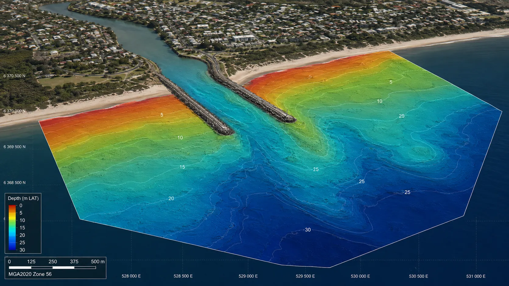
A bathymetric survey captures more than simple depth points. The raw soundings are processed, quality checked and transformed into structured datasets, such as:
Depths are referenced to agreed vertical datums to allow comparison with tidal levels and design elevations. Bathymetric data is combined with shoreline topographic surveys to produce seamless land-sea models that support flood risk analysis and coastal engineering.
Bathymetric data is combined with shoreline topographic surveys to produce seamless land-sea models that support flood risk analysis and coastal engineering.
Where projects demand a fuller understanding of seabed conditions, bathymetric surveying is often integrated with complementary sensors. Side-scan sonar provides acoustic imagery to identify objects, scour and sediment patterns. Sub-bottom profilers investigate layers beneath the seabed, influencing foundation design. In very shallow or environmentally sensitive zones, remotely operated or autonomous surface vessels may be deployed to access areas that are unsafe or impractical for crewed boats.
These technologies mean bathymetric surveying can deliver not only accurate depths but also context about seabed character and potential hazards that affect the planning and execution of coastal works.
A bathymetric survey is required whenever a coastal project could be affected by seabed levels, underwater obstructions or changes in sediment movement. This includes most works that extend below the waterline or rely on accurate water depths for design, navigation or regulatory approval.
Regulators, harbour authorities and design consultants often expect recent bathymetric data before consenting or finalising engineering drawings. The survey is not optional but a precondition for permits, detailed design or construction sign‑off.
Any project that involves vessel access, berthing or safe navigation will almost always need a bathymetric survey. This includes new marina developments, extensions to existing harbours, redesign of navigation channels and commercial port upgrades.
Accurate depth data is required to:
Maintenance dredging campaigns within approach channels or berthing pockets also depend on bathymetric surveys. Pre‑dredge surveys define the existing bed level and volume to be removed. Post‑dredge surveys verify that the design depth has been achieved and provide evidence for contractors, clients and regulators.
Coastal defence schemes require a clear understanding of the seabed profile in front of structures. When designing or refurbishing sea walls, revetments, groynes, rock armour or breakwaters, a bathymetric survey provides the offshore continuation of topographic data and allows engineers to model wave conditions and scour risk.
Understanding how surveying supports mapping coastal change can help project teams assess erosion, sediment movement and the long-term performance of shoreline protection works.
Beach nourishment and sediment management projects depend on bathymetric information. Surveys are used to:
For flood risk assessments in low‑lying coastal areas, combined topo‑bathymetric datasets are often needed to support hydraulic and wave overtopping models.
Projects that place infrastructure on or beneath the seabed will need bathymetric data at feasibility, design and pre‑construction stages. This includes pipelines, power and communication cables, water intakes, sewage outfalls and diffuser structures.
Bathymetric surveys help to:
Coastal and nearshore renewable energy projects also rely on detailed seabed mapping. Accurate bathymetry feeds into resource assessments, foundation design, cable landfall design and navigational risk assessments required by consenting authorities.
Bathymetric surveying should be programmed in the project lifecycle once a coastal site is identified and before final design is fixed. The timing directly affects design accuracy, construction methodology, risk allocation and consent approvals. Out‑of‑date or poorly timed data can lead to design changes during construction, increased dredging volumes and unforeseen hazards.
Survey scheduling must consider project phase, environmental conditions and regulatory requirements. Seabed levels and features can change rapidly due to storms, sediment transport and coastal works, so survey data needs to be recent enough to be reliable for the decisions it supports.
Bathymetric surveying provides valuable insights during the earliest stages of a coastal project, helping designers and stakeholders understand the site's underwater conditions before significant planning or design work begins. By identifying seabed levels, underwater features and potential constraints early, teams can assess whether a location is suitable, compare alternative layouts and estimate construction complexity.
Early survey information also supports more accurate budgeting and scheduling by highlighting factors that may influence construction methods or project costs. Bathymetric data can help identify:
Addressing these considerations during feasibility reduces uncertainty and provides a stronger foundation for the project's next stages.
As a project progresses into detailed design, bathymetric information becomes important for refining engineering solutions and confirming that proposed works align with actual site conditions. Updated survey data enables engineers to establish design levels, coordinate marine and land-based infrastructure, estimate material quantities and develop construction methodologies that reflect the current seabed profile rather than outdated assumptions.
Because seabed conditions can change due to sediment movement, storms, or nearby marine activities, relying on older survey data may introduce unnecessary design risks. Recent bathymetric surveys help validate design assumptions, minimise redesign during construction and improve coordination between engineers, contractors and approval authorities.
Bathymetric surveying continues to provide value throughout construction by measuring how seabed conditions change as work progresses and confirming that completed works comply with design requirements. Regular surveys allow contractors and project managers to compare actual conditions against design models and identify unexpected changes.
Surveys completed during and after construction commonly support:
These ongoing assessments provide an accurate record of completed works while supporting future maintenance, inspections and asset management.
Bathymetric survey data is collected using specialised instruments that measure water depth and seabed features with high precision. The overall process combines accurate positioning, depth measurement and data processing to create a detailed seabed model that can be relied on for design, construction and consent applications.
Although technology can vary by project scale and budget, the core principles remain the same. A vessel or platform moves along planned survey lines while sensors record depths relative to a known reference level; these measurements are then corrected for vessel motion, tides, and sound speed in water to produce usable charts and 3D surfaces.
Accurate depth measurements depend not only on the equipment used to measure the seabed but also on knowing the precise location of every recorded point. Modern bathymetric surveys rely on high-precision Global Navigation Satellite Systems (GNSS), often combined with Real-Time Kinematic (RTK) or differential corrections, to ensure that each measurement is accurately positioned within the project's coordinate system.
Reliable positioning is particularly important for marine structures that must align with existing infrastructure or integrate with terrestrial survey data. Accurate coordinates allow engineers to confidently position breakwaters, pipelines, jetties and navigation channels while ensuring that design drawings, construction layouts and future monitoring all reference the same spatial framework.
Raw depth measurements cannot be used directly for engineering or construction because they are influenced by changing environmental conditions throughout the survey. Vessel movement, tidal fluctuations and variations in the speed of sound through water all affect recorded depths, making correction processes essential for producing reliable seabed models.
Survey planning and water-level reduction should also consider the procedures set out in the Australian Tides Manual, including guidance on tide gauges, tidal observations, datum control and tidal-current measurements.
The wider requirements of coastal and tidal surveying should also be considered, including survey timing, changing tidal heights, sediment displacement and the use of consistent positioning controls.
To achieve consistent and dependable results, surveyors apply a range of adjustments that account for vessel motion, water level changes and local water conditions before finalising the survey dataset. These corrections ensure that depth information represents the seabed relative to the required vertical datum, providing engineers, planners and regulators with confidence that the data is suitable for design, modelling and regulatory approvals.
Bathymetric surveying can be supported by complementary technologies, with the choice depending on the project's objectives, site conditions and the level of detail required. While echo sounders remain the primary tool for measuring water depths, additional sensors provide valuable information about seabed characteristics, buried features and underwater hazards.
Common technologies used alongside bathymetric surveys include:
Selecting the appropriate combination of technologies ensures the survey delivers the information needed for design, construction and environmental assessment without collecting unnecessary data.
Bathymetric survey data underpins almost every technical decision on a project. It defines the precise shape and depth of the seabed so designers, engineers and regulators can understand existing conditions, predict how they will change and check that constructed works match the design.
The data is delivered as depth soundings, digital terrain models and contour plans that feed directly into engineering design software, numerical models and statutory documentation. Its use spans the full project lifecycle from concept planning to long-term monitoring.
Survey data provides the foundation for many decisions by defining the underwater environment before construction begins. Engineers use this to establish design levels, determine foundation locations, assess dredging requirements and identify seabed features that could influence the stability or constructability of marine infrastructure. When combined with terrestrial survey data, bathymetric information creates a land-to-sea model that supports coordinated planning.
The survey data also assists in optimising infrastructure layouts by reducing uncertainty during design. Reliable seabed information enables project teams to evaluate different construction approaches, minimise conflicts with existing marine assets and refine structural designs before work begins.
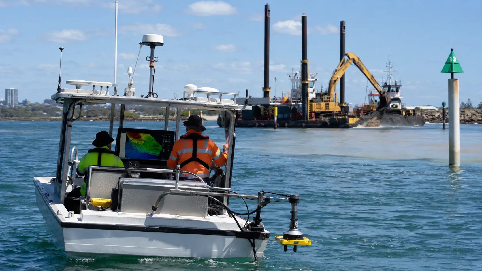
Harbour authorities and port operators rely on bathymetric surveys to maintain safe navigation. Survey data feeds into chart updates and pilotage guidance, calculation of available under-keel clearance for specific vessel drafts and identification of high spots or siltation that may restrict access.
For capital dredging, the pre-works survey defines existing volumes while design models use bathymetry to plan dredge depths, slopes and disposal strategies. During maintenance dredging, repeated surveys are compared to earlier data to calculate infill rates, confirm contract quantities and verify that required depths have been achieved across berths and channels.
Coastal and estuarine models depend on accurate seabed geometry. Bathymetric data is used to build hydraulic and sediment transport models that predict:
These outputs inform flood risk assessments, shoreline management plans and coastal erosion studies. Environmental specialists also use bathymetric surfaces to map habitats, identify reef and sandbank features and define depth-related ecological zones.
On operational projects, repeat bathymetric surveys enable condition monitoring. Changes in bed level are tracked to identify scour at structure toes, settlement beneath quay walls, infill around outfalls or encroachment of channels towards protected assets. This supports maintenance planning and demonstrates regulatory compliance.
Survey accuracy depends on more than the quality of the echo sounder. A project that relies on poor depth data risks incorrect dredge volumes, badly aligned structures and unexpected navigation hazards. Understanding what affects accuracy helps determine the level of survey needed and how recent it must be.
Several technical and environmental factors can shift depths by tens of centimetres or more if they are not correctly measured and controlled. For coastal developments, that margin of error can be the difference between a design that performs as intended and one that fails in service.
The choice of instrument impacts achievable accuracy. Single-beam echo sounders record depths along a track line, which may be sufficient for small access channels or simple foreshore profiles. Multibeam systems measure a full swath of the seabed and are usually required where detailed seabed morphology or volume calculations are critical.
Calibration is just as important as equipment type. Regular bar checks and patch tests are needed to identify any offsets in depth, pitch, roll or heading. Neglecting these checks can introduce systematic errors across an entire survey area. GNSS receivers must be configured for the appropriate correction service and referenced to the correct datum to avoid vertical and horizontal misplacements of structures.
All depth data must be reduced to a consistent vertical datum. Tidal range, storm surge and atmospheric pressure can alter water levels by more than a metre. If tide gauges are not correctly referenced or if predicted tides are used where local anomalies exist, then the final charted depths will be unreliable. Projects that require tight vertical tolerances demand an accurate tide model and well-maintained gauges near the site.
Sound speed in water controls the travel time of acoustic pulses. Variations caused by temperature, salinity or freshwater input from rivers will change the apparent depth unless sound speed profiles are measured and applied. In exposed coasts or estuaries where salinity gradients are strong, uncorrected sound speed can distort multibeam data and misrepresent slopes and scour around structures.
Seabed type also influences accuracy. Soft mobile sediments can shift between survey passes, particularly around tidal inlets or dredged approaches, which means that an older survey may no longer represent current conditions even if it was accurate at the time of acquisition. Hard rocky seabeds produce stronger acoustic returns but can create multiple echoes around boulders and ledges.
Sea state and vessel motion affect how precisely the seabed position is mapped. Pitch, roll and heave must be measured with a motion reference unit and correctly integrated with positioning data. Rough conditions increase noise in depth and horizontal position and may make high-accuracy work unsuitable until conditions improve.
Overall positioning quality underpins the whole survey. Reliable GNSS corrections, good satellite geometry and an appropriate local coordinate system are essential where structures must tie into onshore works or existing marine infrastructure.
Clarifying survey requirements early prevents costly redesigns, consent delays and construction risks. Whether a project involves a small jetty or a major waterfront development, regulators and designers expect specific bathymetric information, collected to defined standards and within a recent timeframe.
Survey requirements depend on project type, location, water depth and regulatory pathway. They must respond to navigation safety, environmental protection and structural design needs, so a clear brief and alignment with authorities are essential before fieldwork begins.
A bathymetric survey is usually mandatory when a project affects navigation, coastal structures or seabed levels.
Planning authorities, harbour or port authorities and environmental regulators often specify minimum survey extents and accuracy classes. Where navigation is involved, survey requirements are typically aligned with the IHO Standards for Hydrographic Surveys, with the required survey order and level of detail determined by navigational risk and intended data use.
Projects in environmentally sensitive areas require bathymetry that supports habitat assessment and sediment transport studies. Regulators may insist on coverage beyond the immediate construction footprint to capture potential impact zones.
Survey coverage must extend far enough to inform design and risk assessment. For a new marina, this usually includes access channels, manoeuvring areas and adjacent seabed where sedimentation or scour may occur. For coastal defences, the survey area spans offshore to closure depth and alongshore beyond the structure ends to understand coastal processes.
Resolution and accuracy are driven by project scale and risk profile. High‑risk or high‑value infrastructure on the order of a few centimetres relative to a recognised vertical datum. Smaller recreational facilities may accept lower resolution provided critical areas such as vessel approaches and berths are surveyed at greater detail.
A clear requirement for integration with terrestrial topographic surveys is also essential. Designers commonly need a seamless land‑sea surface, so specifications should state the coordinate system, vertical datum and tidal or hydrodynamic corrections.
Survey requirements must be mapped directly to consent, safety and engineering deliverables. Regulators often expect bathymetric data that supports navigational risk assessments and updated charts, coastal process modelling and environmental impact assessments and habitat mapping.
For projects in New South Wales, the available NSW coastal management guidance can help project teams understand coastal hazards, erosion, inundation and the technical information that may need to support planning decisions.
Designers rely on the same dataset for foundation levels, dredge volumes, scour assessments and construction access planning. Where construction will stage over several years, the requirement may include repeat surveys to monitor seabed change and verify dredging or maintenance outcomes.
Early dialogue with planning bodies, harbour authorities and design teams is vital to confirm the survey standard, validity period and any need for multi‑beam, single‑beam or combined techniques. This ensures that once collected, the bathymetric data satisfies all technical and statutory requirements without the need for repeat mobilisation.
A bathymetric survey is a fundamental part of responsible coastal development, supporting informed design, effective risk management and regulatory compliance. Accurate seabed data underpins decisions for marine infrastructure, dredging, navigation safety, environmental assessments and asset performance. Where water depths, sediment movement or regulatory requirements can affect project outcomes, reliable survey data provides the confidence needed for sound planning and engineering decisions.
As coastal projects become more complex, commissioning a bathymetric survey early helps reduce uncertainty, manage costs and minimise risk throughout the project lifecycle. By delivering accurate and reliable hydrographic surveying services, MCS Surveyors helps clients decide and build coastal infrastructure on dependable seabed data.